

Hurricane Ian lands in Florida same place, nearly same time as 'Charley' in 2004

The latest on Hurricane Ian's path
Chief meteorologist David Chandley gives the latest on Hurricane Ian's path. The metro Atlanta area could be spared this weekend.
There are striking similarities between Hurricane Ian and Hurricane Charley, including when and where they touched down in Florida.
The eye of Hurricane Ian made landfall around 3:05 p.m. near Cayo Costa, Florida as a dangerous Category 4 storm with winds of 150 mph, according to the National Hurricane Center (NHC) and Central Pacific Hurricane Center (CPHC).
The timing and location are oddly familiar. According to FEMA, In 2004 Hurricane Charley ramped up to a Category 4 storm right before landing near Cayo Costa, Florida at approximately 3:45 p.m. on Aug. 13 of that year.
Charley was considered small, yet powerful. What started off as a tropical depression on Aug. 9, quickly turned into a deadly hurricane in just three days. At least 32 people were killed between Florida, Cuba and Jamaica. Over 1.7 million people evacuated from Florida, western and central Cuba and South Carolina.
Charley left the U.S. with nearly $15 billion in damages.
Meanwhile, Ian has reportedly already killed at least two people in Cuba. Its lasting damage is unpredictable.
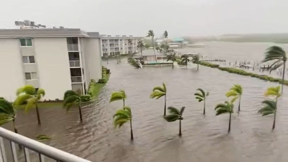
A screengrab from footage posted to Twitter shows flooding in Naples, Florida, around 1 p.m. on Sept. 28, 2022, ahead of Hurricane Ian landfall. Credit: @Chad71777859 via Storyful
Now, Georgians wait in the calm before the storm.
A LOOK AT SOME OF THE MOST DEADLY HURRICANES IN THE U.S.
If Ian stays on its current track, residents across the state can expect to feel some sort of impact later this week, especially southeastern Georgia. FOX 5 Storm Team meteorologists maintain that its severity depends on your proximity to the eye of the storm.
According to National Hurricane Center's forecast, North Georgia could see high winds and some heavy rain as early as Friday, which would continue into Saturday morning.
Current projections show Atlanta just out of the center's reach. Meaning, the metro area could be spared from the most severe impacts, which include flash flooding, damaging wind gusts and tropical tornadoes. However, this is subject to change.
Keep up with the latest by downloading the FREE FOX 5 Storm Team app and following @FOX5StormTeam on Twitter.