

Storms move through Georgia

Wednesday Night Weather Update
A quieter night after a stormy day. A few early morning showers, but most areas will be partly cloudy and mild with temps in the 60s. Mix of sun and clouds Thursday afternoon with highs in the low 80s, only a few isolated storms. Drier and hotter by Friday, here is the latest.
ATLANTA - The FOX 5 Storm Team is tracking numerous showers and potentially severe thunderstorms are expected in the 48-hour period from Wednesday morning to Thursday evening across north Georgia.
A surface boundary is currently stalled across south-central Georgia Wednesday into Thursday and will be the focus for more widespread showers and thunderstorms with the highest rain and thunder chances along where the boundary sets up.
KEEP UP WITH THE LATEST BY DOWNLOADING THE FREE FOX 5 STORM TEAM APP AND FOLLOWING @FOX5STORMTEAM ON TWITTER
A Flood Watch is in place for Bibb, Bleckley, Crawford, Crisp, Dodge, Dooly, Houston, Jones, Monroe, Peach, Pulaski, Telfair, Twiggs, Wilcox, Chattahoochee, Harris, Lamar, Macon, Marion, Meriwether, Muscogee, Pike, Schley, Stewart, Sumter, Talbot, Taylor, Troup, Upson and Webster counties through Thursday evening. These areas could see 2 to 5 inches of rain which could lead to excessive ponding on roadways and in low-lying areas, as well as runoff which would swell creeks, streams, and rivers.
Here is the latest:
6:20 P.M. || Georgia Power is reporting about 8,465 outages statewide and the Georgia Electric Cooperatives reporting about 8,834 customers without power.
5 P.M. || Hail has been reported across Georgia on Wednesday. What does it look like near your area? Submit photos and video the FOX 5 Storm Team app.
4:50 P.M. || Georgia Power is reporting about 13,342 outages statewide and the Georgia Electric Cooperatives reporting about 4,875 customers without power.
TROUP COUNTY STORM DAMAGE
3:35 P.M. || Troup County Sheriff's Office says it is busy assisting with "vehicle accidents" reports of trees and power lines down in the northeastern potion of Troup County.
3:32 P.M. || A new Severe Thunderstorm Warning has been issued for parts of Cleburn and Randolph counties in Alabama. A line of storms near Annioston is capable of 60 mph winds.
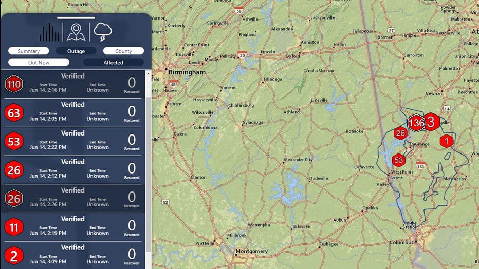
POWER OUTAGES
3:25 P.M. || More than 3,500 customers are currently without power in Henry County according to Georgia Power. Click here for the power outage map.

Georgia Power outage map
Diverse Power customers in Troup county are also being affected by several outages. Check their map here.
A Severe Thunderstorm Warning continues until 3:45 p.m. for Jackson, Flovilla and Jenkinsburg.
3:06 P.M. || A cluster of severe storms on the south side of Atlanta are moving SE. A Severe Thunderstorm Warning now includes parts of Spalding, Newton and Butts Co.
SEVERE THUNDERSTORM WARNING
2:55 P.M. || A new Severe Thunderstorm Warning has been issued for parts of Clayton, Fayette, Henry and Spalding counties until 3:30 p.m.
2:53 P.M. || A Severe Thunderstorm Warning is in effect for Fayetteville, Hampton and Lovejoy until 3:30 p.m.
2:45 P.M. || Severe Thunderstorm Warning issued for parts of Henry Co.
REPORT OF TORNADO
2:39 P.M. || A large and dangerous tornado is being reported by Georgia Weather Online and others in the Arlington area.
2:35 P.M. || A Severe Thunderstorm Warning is in effect until 3 p.m. for Senoia, Sharpsburg and Turin in Georgia.
CLAYTON COUNTY SCHOOLS
2:19 P.M. || Clayton County Schools is advising families with children participating in the district's summer program to prepare them for potential conditions on Thursday. This means they should be prepared with rain gear, including umbrellas, if available. It is possible that weather conditions may cause delays in transportation. The school district will continue to monitor conditions throughout the evening and will make adjustments as needed,
2:18 P.M. || A Severe Thunderstorm Warning issued for parts of Coweta and Meriwether counties. A storm near Hogansville is moving NE at 55 mph.
TROUP COUNTY SCHOOLS
2:15 P.M. Troup County School System decides to cancel ALL student activities and athletics for the rest of the day. TCSS is also canceling any district meetings that include employees of community members.
TORNADO WARNING
2:07 P.M. || A Tornado Warning has been issued for western Dougherty County in southwestern Georgia; northwestern Baker County in southwestern Georgia; and southern Calhoun County in southwestern Georgia. The warning is in effect until 2:45 p.m., according to National Weather Service.
SEVERE THUNDERSTORM WARNING
2 P.M. || A Severe Thunderstorm Warning has been issued for LaGrange, Hogansville and Corinth until 2:45 P.M.
Georgia Power says they are monitoring weather forecasts around the clock, with teams prepared to restore power for customers safely and as quickly as weather conditions allow should any service interruptions occur. They are offering the following tips and tools:
Electrical Safety Tips During Storms
- Never touch any downed wire or low-hanging wires.
- Never pull tree limbs off power, telephone or cable lines or attempt to repair electrical equipment damaged in a storm.
- Never go near chain link fences – downed power lines or lightning strikes may energize the entire length of the fence.
- Avoid walking through flooded areas or puddles as they may be energized by downed power lines.
- Never walk into areas where crews are at work. Please do not approach crews as they perform their important tasks safely.
- If driving near work crews, obey the "move-over law", which requires drivers to move over a lane when possible if a utility vehicle with displayed warning lights is parked on the side of the road.
Tools to Stay Informed
- Outage Alerts – Subscribe to the free Georgia Power Outage Alert service to receive personalized notifications and updates via text message.
- Outage & Storm Center – Available at georgiapower.com/storm, customers can visit this site to sign up for Outage Alerts, report and check the status of outages, and access useful safety tips and information. Customers can report and check the status of an outage 24 hours a day by contacting Georgia Power at 888-891-0938.
- Outage Map – Housed within the Outage & Storm Center, Georgia Power’s interactive Outage Map provides near real-time information, allowing users to see where outages are occurring across the state and track estimated restoration times.
- @GeorgiaPower on Twitter – Follow @GeorgiaPower on Twitter for storm tips, outage updates, customer service and more.
For additional tips on preparing for severe weather, visit GeorgiaPower.com/Storm.
SEVERE THUNDERSTORM WARNING
1:36 P.M. || A Severe Thunderstorm Warning has been issued for Buena Vista, Doyle and Tazewell.
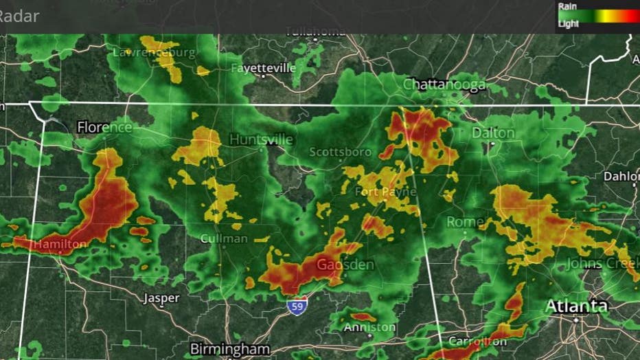
Interactive radar at 1:35 p.m.
1:25 P.M. || A Severe Thunderstorm Warning has been issued for Carrollton, Villa Rica and Bremen until 1:45 p.m.
1:20 P.M. || A Severe Thunderstorm Warning has been used for Carroll and Haralson counties until 1:45 p.m.
TORNADO WARNING
1:17 P.M. || A Tornado Warning has been issued for Renfroe and Cusseta until 1:45 p.m.
12:16 P.M. || A Tornado Watch has been issued for parts of Alabama and Georgia until 7 p.m. Counties include Meriwether, Heard, Clay, DOugherty and Irwin.
A Severe Thunderstorm Warning has been issued until 1:30 p.m. for Columbus and Upatoi in Georgia and Phenix City in Alabama.
Additionally, a Flood Watch has been issued for Randolph County in Alabama and Troup, Meriwether, Pike, Upson and Lamar counties in Georgia.
Click here for all of the weather alerts.
KEEP UP WITH THE LATEST BY DOWNLOADING THE FREE FOX 5 STORM TEAM APP AND FOLLOWING @FOX5STORMTEAM ON TWITTER
EARLIER STORY
Numerous showers and potentially severe thunderstorms are expected in the 48-hour period from Wednesday morning to Thursday evening across north Georgia.
A surface boundary is currently stalled across south-central Georgia Wednesday into Thursday and will be the focus for more widespread showers and thunderstorms with the highest rain and thunder chances along where the boundary sets up.

Wednesday morning weather forecast
Expect some periods of thunderstorms and rain today with most of the storm hitting Middle Georgia. Today won't be a washout, however.
An initial round of storms is currently moving through west central Georgia and is expected to continue through the morning and early afternoon.

A secondary round of storms is forecast to begin overnight tonight into tomorrow morning with the main risks for both lines being large hail, damaging wind gusts and a few tornadoes.
Multiple rounds of showers and thunderstorms are forecast through Thursday evening, mainly for areas along and south of Interstate 20. Thunderstorm activity will produce locally heavy rainfall, with the potential for repeated heavy rains over the same areas. As a result, 2 to 5 inches of rain is possible through Thursday evening, with locally higher amounts possible.
As result of the back-to-back rounds of storm, high temperatures will remain well above-average in the mid-to-upper 70s throughout the day. Drier and warmer conditions return to the area Friday.