

Winter Storm Warning: Wintry mix continues into Sunday night, damaging winds possible

Storm Alert Day: Ice possible as temperatures fall overnight
A Winter Storm Warning remains in effect until midnight Monday in northeast Georgia, and ice accumulation is possible on roads overnight.
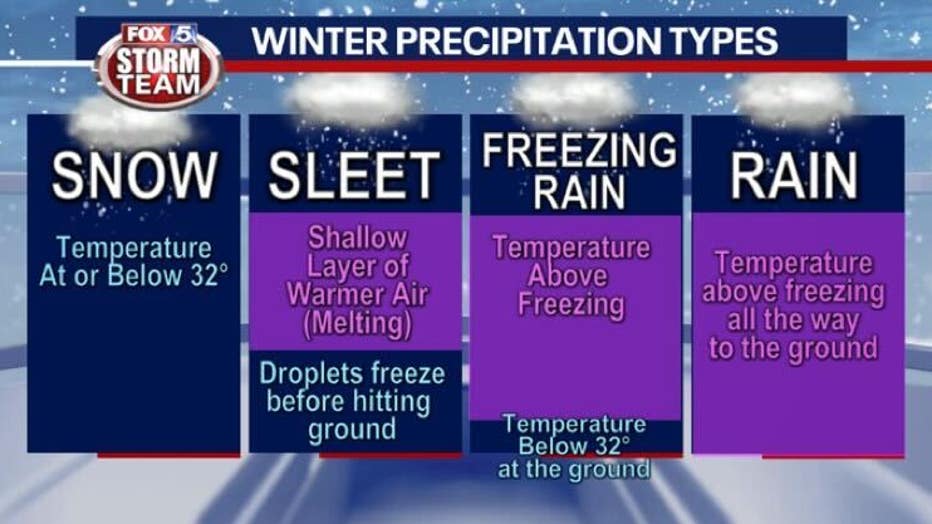
ATLANTA - Snow, sleet, freezing rain, and rain: The FOX 5 Storm Team continues to track a dynamic storm system that swept across north Georgia.
Areas northeast of Atlanta experienced heavy snowfall through Sunday evening.
Pockets of freezing rain and a rain and snow mix impacted metro Atlanta before precipitation switched over to snow late Sunday morning.
The National Weather Service has issued a Winter Storm Warning until midnight Monday in northeast Georgia and the northwest corner of the state:
- Dade County
- Walker County
- Fannin County
- Gilmer County
- Union County
- Towns County
- Chattooga County
- Pickens County
- Dawson County
- Lumpkin County
- White County
- Stephens County
- Forsyth County
- Hall County
- Banks County
- Jackson County
- Franklin County
- Madison County
- Hart County
- Gwinnett County
- Barrow County
The warning extends until 7 a.m. on Sunday in Clay County and 8 a.m. in Rabun County and Habersham County.
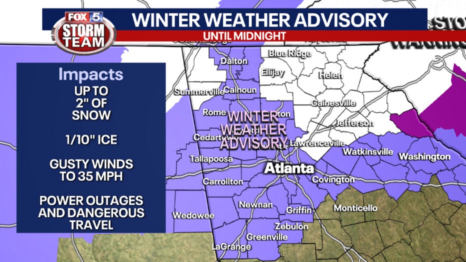
North and central Georgia winter weather advisory on Jan. 16, 2022. (FOX 5 Atlanta)
Areas of north and central Georgia are covered by a Winter Weather Advisory until midnight on Monday. More areas were added to the advisory on Sunday morning:
- Catoosa County
- Whitfield County
- Murray County
- Gordon County
- Floyd County
- Bartow County
- Cherokee County
- Polk County
- Paulding County
- Cobb County
- North Fulton County
- Clarke County
- Oconee County
- Oglethorpe County
- Haralson County
- Carroll County
- Douglas County
- South Fulton County
- DeKalb County
- Rockdale County
- Walton County
- Newton County
- Morgan County
- Greene County
- Heard County
- Coweta County
- Fayette County
- Clayton County
- Spalding County
- Henry County
- Troup County
- Meriwether County
- Pike County
GEORGIA WINTER WEATHER: ROAD CONDITIONS, POWER OUTAGES IN NORTH GEORGIA, METRO ATLANTA
Some parts of the viewing area could see measurable snow, between two and five inches.
A flash event of mixed precipitation changing to snow hit the Atlanta area at around 10 a.m.
A second band made its way toward Downtown early afternoon.
Precipitation types may not be constant throughout. As the coldest air comes in behind the system, many more areas will change over to snow throughout Sunday afternoon.
SNOWFALL IN GEORGIA: WINTER WEATHER SCENES FROM AROUND THE STATE
The entire FOX 5 Atlanta viewing area is under a wind advisory until 7 p.m. Monday.
The wind gusts were causing power outages and road closures throughout the metro area on Sunday morning. Wind began to recede by about 10 a.m. on Sunday.
By late morning the strongest winds were in the northeast of the state between 20 and 30 miles per hour.
The bulk of the storm system will exit the viewing area by late Sunday night or early Monday morning. With that said, there will still be lingering impacts Monday morning with a refreeze event likely.
Keep up with the latest by downloading the FREE FOX 5 Storm Team app and following @FOX5StormTeam on Twitter.