

Heat wave: Atlanta hits 100, afternoon severe storms threat continues
ATANTA - Oppressive heat and daily rounds of thunderstorms will persist across Georgia through the end of the week, prompting the National Weather Service to extend heat advisories and warn of potential downburst winds and locally heavy rainfall.
Atlanta officially hit 100 degrees at 4:40 p.m. Tuesday. This is the first time triple-digit temps have come to Atlanta since last summer. The peak heat index in the city was 107.
RELATED: Blistering temps on the way for North Georgia: Know how to stay cool

Tuesday night forecast
After hitting 100 degrees for the first time in more than a year, Atlanta prepares for some evening thunderstorms and more seasonal temperatures the rest of the week. Much milder days are expected by the weekend. Here are the details.
Heat Advisories
What we know:
The Heat Advisory remains in effect until 8 p.m. Wednesday for much of north and central Georgia. Forecasters say heat index values between 105 and 109 degrees are expected in the affected areas. Overnight temperatures are forecast to provide little relief, with conditions quickly intensifying again by Tuesday morning.
Counties under the advisory include: Dade, Walker, Catoosa, Whitfield, Murray, Chattooga, Gordon, Floyd, Bartow, Cherokee, Forsyth, Hall, Banks, Jackson, Madison, Polk, Paulding, Cobb, North Fulton, Gwinnett, Barrow, Clarke, Oconee, Oglethorpe, Wilkes, Haralson, Carroll, Douglas, South Fulton, DeKalb, Rockdale, Walton, Newton, Heard, Coweta, Fayette, Clayton, Spalding, Henry, Butts, Troup, Meriwether, Pike, Upson, Lamar, Monroe, Harris, Talbot, Taylor, Crawford, Muscogee, Chattahoochee, Marion, Schley, Macon, Peach, Houston, Stewart, Webster, Sumter, Dooly, Crisp, Pulaski and Wilcox.
The Weather Service advises residents to drink plenty of fluids, stay indoors in air-conditioned spaces, avoid direct sunlight, and check on vulnerable neighbors and family members. Those working outdoors are urged to take frequent breaks in shaded or cool environments.
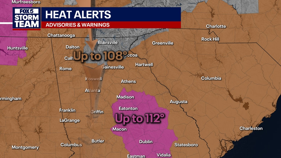
The Extreme Heat Warning has been allowed to expire.
SEE ALSO: Metro Atlanta bracing for record-breaking heat this week
Summertime weather pattern continues
What they're saying:
Scattered thunderstorms and a potential cooldown are in store for Georgia residents this week, with FOX 5 Storm Team meteorologist Johnathan Stacey warning of increasing rain chances and a drop in temperatures by the weekend.
"It feels like it’s around 104," Stacey said during Tuesday’s evening forecast. "In terms of the rain chances, they are going up as we get deeper into the evening hours."
At 7 p.m., there will be a 30% chance of showers. Stacey said rain activity is expected to intensify after sunset, with isolated storms potentially turning strong. By 8 p.m., cells were already forming over Spalding, Pike, Lamar, and Bibb counties. Thunderstorms were also expected to pop up in Cobb, Ackworth, Marietta, Buckhead, and throughout central and north Fulton County, including along Georgia 400 and into Forsyth County.
"A rumble of thunder down there at the airport" may lead to a late-night ground stop, Stacey warned.
Rain was also building along the South Carolina-Georgia state line from Rabun County through Franklin County. By 9 p.m., activity was forecast to move into Forest Park, Stonecrest, and the surrounding areas of north Clayton and south DeKalb counties, including Henry and Stockbridge.
By late evening and into the early morning hours, heavier downpours were expected along I-85 in Hart, Stephens, Franklin, and Banks counties. Additional cells were forecast to stretch into Oglethorpe and Barrow counties. Between 11 p.m. and midnight, scattered storms were predicted along corridors between I-85 and I-20, including Butts, Jasper, and Putnam counties.
"Wednesday morning should be dry for the most part, but don’t be surprised if you wake up to some water on the ground," Stacey said, noting that the atmosphere remains unstable.
Rain chances rise to 60% on Wednesday and Thursday, before easing to around 40% through the weekend. Temperatures will start to fall as a front moves into the region.
"We will look for a high of 93 degrees tomorrow, 91 for Thursday and Friday," Stacey said. "By Saturday, that front is to the south of the area, so temperatures have plunged from 91 to 84. I can use ‘plunged’ at this time of the year. Yes, this is a pretty solid drop."
By Sunday, parts of northeast Georgia may not climb out of the 70s. "We could actually spend most of our day between like 71, 75, 76 degrees, especially across northeast Georgia as a wet wedge builds in place," Stacey said.
The wedge pattern is expected to begin breaking down Monday, allowing for drier air and the return of sunshine.
Thunderstorm threat despite heat
What they're saying:
Thunderstorms are expected each afternoon and evening this week. Storms could produce wind gusts up to 50 mph and localized flooding. The highest chances for storms on Tuesday and Wednesday will fall between 4 p.m. and midnight, particularly in central and northern Georgia.
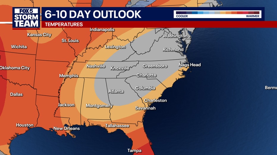
By Thursday, a weak frontal boundary will move into the region and stall, keeping precipitation chances elevated. Another front is expected to arrive by Friday and slowly drift south through the weekend. That system, combined with high pressure building in from the northeast, is forecast to usher in a cooler, more stable air mass.
Temperatures are expected to fall into the 70s and 80s across northern Georgia by Saturday, with the entire state seeing lower readings Sunday and Monday.
DOWNLOAD THE FOX LOCAL APP FOR THE LATEST FORECASTS
How hot will it get?
Local perspective:
Here is what is expected for the different regions in Georgia:

Metro Atlanta
- Wednesday: High of 91 with an 80% chance of storms.
- Thursday: High of 91, 70% chance of storms.
- Weekend: Highs in the upper 70s to low 80s with continued storm chances.
Rome
- Wednesday: High of 94 with an 80% chance of storms.
- Friday: Highs near 93 with thunderstorms likely.
- Saturday-Sunday: Cooler, highs in the mid-80s.
LaGrange
- Wednesday: High of 90, heat index up to 100, 60% chance of rain.
- Weekend: Highs drop to the low 80s with widespread storms likely.
Eatonton
- Wednesday: High near 92, heat index reaching 104, 60% chance of storms.
- Friday: Sunny with a high near 95, 60% storm chance later in the day.
Athens
- Wednesday: High of 92, heat index around 103, 60% storm chance.
- Thursday-Friday: Highs near mid-90s with strong afternoon storm potential.
- Weekend: Cooler, highs drop to the low 80s by Sunday.
Gainesville
- Wednesday: High of 90 with an 80% chance of thunderstorms.
- Saturday-Sunday: Highs in the upper 70s to low 80s, continued rain.
Blairsville
- Wednesday: High near 85 with showers and storms likely.
- Weekend: Highs in the mid to upper 70s, heavy rain expected.
Beating the heat
What you can do:
In addition to taking precautions outdoors, authorities are reminding residents never to leave children or pets inside unattended vehicles, where temperatures can reach lethal levels within minutes.
For those working outside, OSHA recommends frequent breaks in shaded or air-conditioned areas and being alert to signs of heat stroke or exhaustion. Emergency services should be called immediately if someone shows signs of heat-related illness.
Cooling centers in Georgia
What's next:
Officials urge residents to prepare for prolonged heat by staying hydrated, limiting time outdoors during peak hours, and checking on elderly or vulnerable neighbors.
Cooling centers will be available in many communities.
- DeKalb County cooling centers
- City of Atlanta cooling center
- Cobb County cooling center
- Clayton County cooling centers
- Douglas County cooling centers
- Gilmer County cooling center
- Jasper and Newton counties cooling centers
- Marietta cooling center
- Stockbridge cooling centers
The Source: The FOX 5 Storm Team and the National Weather Service provided the original forecast for this article.