

LIVE WEATHER BLOG: Second round of storms coming overnight

Thursday afternoon forecast
The FOX 5 Storm Team is continuing to track a severe storm threat to north Georgia. Here's a look at the timing, intensity, and when these storms will move out.
ATLANTA - North Georgia remains on edge as the threat of severe storms continues throughout Thursday.
The severe weather threat for most of the state has increased to a Level 3, which means an "enhanced threat level." The primary threats remain damaging winds and hail, but isolated tornadoes are possible.
The storm system has already caused serious damage and at least two deaths in other states and has triggered multiple Tornado and Severe Thunderstorm Warnings in Georgia.
LIST OF SCHOOL CLOSINGS AND DELAYS
Here is the latest:
2:55 p.m. - Some roads in Dalton have reopened after flooding forced their closure overnight.
2 p.m.: A shelter has opened in Gilmer County at the warming center for anyone who needs it. Pets are welcome and will be provided a kennel.
1 p.m.: The National Weather Service has issued a Tornado Warning for parts of Larens and Dodge counties in central Georgia until 1:30 p.m.. Officials say radar indicates a rotation near Plainfield, Georgia. Another Tornado Warning is in effect for Macon, Dooly, Schley, and Sumter counties until 1:45 p.m.
Residents should take cover and move to a basement or lowest floor of a sturdy building to avoid debris.
12:53 p.m.: A Tornado Watch for central Georgia that was set to expire at 1 p.m. has now been extended.
The watch is now in effect until 3 p.m. for Bibb, Crawford, Houston, Peach, TWiggs, Wilkinson, Glascock, Jefferson, Washington, and Upson counties.
The advisory is extended until 5 p.m. for Bleckley, Crisp, Dodge, Dooly, Laurens, Montgomery, Pulaski, Telfair, Wheeler, Wilcox, Emanuel, Johnson, Toombs, Treultlen, Chattahoochee, Harris, Macon, Marion, Muscogee, Schley, Stewart, Sumter, Talbot, Taylor, and Webster counties.
12:20 p.m.: The Gilmer County Sheriff's Office is advising residents to use extreme caution if driving on ANY road in Gilmer County. Many roads have culverts that have washed away or deep standing water that is not draining. There are also numerous trees that are down.
11:50 a.m.: The Pickens County Sheriff's Office says Whitestone Road is currently flooded and closed north of Imerys Marble Plant.
11:34 a.m.: Flight delays are being reported at Hartsfield-Jackson Atlanta International Airport because of a ground stop put in place because of stormy weather. The ground stop could last as long as an hour or more. Check FlightAware for additional information.
11:22 a.m.: FOX 5 Storm Team forecasts predict another wave of rain will hit north Georgia and the metro Atlanta area early Friday morning. While the models remain in flux due to the speed of the storm system, Georgia should experience heavy rain and winds beginning at 4 or 5 a.m. and continuing through 9 a.m.
11 a.m.: Hartsfield-Jackson Atlanta International Airport has issued a ground stop due to thunderstorms in the area. The stop will affect all flights until 11:45 a.m.
10:30 a.m.: Georgia Power Co. is reporting a number of power outages in north Georgia. In the Chatsworth/Ellijay area, 3,817 customers are currently without power. Jackson EMC is also reporting more than 1,000 customers without power in several counties, including Banks, Madison, Hall, Barrow, Jackson, Clarke, Gwinnett and Lumpkin.
9:30 a.m.: Metro Atlanta may be experiencing a relative lull, but a new line of storms is already ramping up in northeastern Alabama.
While models show the next wave hitting the area around noon, the storm is picking up speed and may be here before that expected time.
Once that wave heads into south Georgia, the area will have a period of quiet and calm until another round of storms passes through the area overnight.
9 a.m.: At least one large tree fell on Cherokee Avenue near Grant Park as the storm moved through Atlanta.

8:41 a.m.: Dalton Police Department is reporting that several roads are closed because of flooding.
8:30 a.m.: The line of heavy rain and wind has reached the Perimeter just in time for the morning rush hour. The system has left many parts of the metro Atlanta area with low visibility as it moves through.
The faster the storm goes, the faster Georgia gets to the late afternoon break, which could last until late Thursday night.
The Flash Flood Warning in effect for northern Dawson County, southern Gilmer County, southwestern Lumpkin County, northern Pickens County, northern Gordon County, southwestern Murray County, and south central Whitfield County has been extended until 9:30 a.m. Another Flash Flood Warning is in effect for central Habersham County and Stephens County until 10:15 a.m.
In Hiawassee, Georgia, a FOX 5 viewer shared photos of fallen trees blocking Owl Creek Road.

More than 6,000 Georgians remain without power at this time.
7:55 a.m.: The National Weather Service has issued a Severe Thunderstorm Warning for Paulding County, southern Cherokee County, northwestern DeKalb County, southwestern Forsyth County, northeastern Haralson County, Cobb County, northeastern Douglas County, northern Gwinnett County, northeastern Fulton County, eastern Polk County, and southern Bartow County until 8:30 a.m. after tracking a storm currently over Acworth.
In Gilmer County, the school system's original two-hour delay has changed to a full closing for the day.
7:39 a.m.: A Severe Thunderstorm Warning is in effect for east central Cherokee County, Forsyth County, northeastern Gwinnett County, southeastern Dawson County, and southern Hall County until 8:15 a.m.
7:25 a.m.: Dade and Walker County Schools have announced two-hour delays out of an abundance of caution due to road conditions.
In Union County, one school will move to virtual learning due to power outages in the area.
"Woody Gap Schools will observe an online learning day today, Thursday, May 9th, 2024. Students should work on their online assignments or work packets as assigned. If you are dealing with power issues, your teachers will work with you.," Union County school officials wrote on Facebook. "The Blairsville Campus will remain open and on a normal schedule. If you are impacted by power outages, downed trees, or flooded roads, your child's school will excuse either a tardy or absence today. Please be sure to use extreme caution when commuting to school this morning."
6:34 a.m.: Gilmer County Schools have announced they will operate on a two-hour delay for Thursday morning due to the weather. Whitfield County Schools and Habersham County Schools will be closed due to serious flooding and dangerous driving conditions.
A Severe Thunderstorm Warning is in effect for southern Murray County, central Floyd County, south-central Whitfield County, southeastern Walker County, Gordon County , and Chattooga County until 7:15 a.m.
6:20 a.m.: The National Weather Service in Peachtree City has issued a Severe Thunderstorm Warning for northern Gilmer County, Murray County, Northwestern Union County, and Fannin County until 7 a.m.
6:10 a.m.: A Severe Thunderstorm Warning is in effect for Catoosa, Whitfield, Walker, and Dade counties in northwestern Georgia. The warning is in effect until 6:45 a.m.
5:50 a.m.: A Tornado Watch has been issued for parts of Georgia, North Carolina and Tennessee until 1 p.m. The watch includes all the metro Atlanta area and all of north Georgia through south of Macon.
5:30 a.m.: FOX 5 cameras saw severe flooding and damage to an Exxon gas station on the outskirts of Dalton in Whitfield County.
Crews have shut down roads due to the high levels of groundwater in the area.
5:10 a.m. A Severe Thunderstorm Warning has been issued for eastern Clarke County, northwestern Wilkes County and Oglethorpe County until 6 a.m. The National Weather Service in Peachtree City reported 60 mph wind gusts and quarter-sized hail.
5 a.m. Many areas of north Georgia are bracing for another round of heavy rains after experiencing flooding through the night.
Officials in Whitfield County tell FOX 5, many streets were flooded and became basically impassible, causing cars to be stuck in the water. Crews had to rescue a few drivers and residents who became trapped in their homes.
In Walker County, officials did not report any specific damage but said they believed a touchdown near Flaherty Road that may have knocked trees down.
Murray County is asking residents to stay off the roads as much as possible while they deal with flooding in Chatsworth.
Georgia Power reports that more than 5,000 Georgians around the state are currently without power.

Tracking severe storms across Georgia
Parts of north Georgia have already experienced heavy rains and flooding, and another wave of storms is on its way to the Peach State.
4:40 a.m. - The next wave of storms is crossing through Tennessee, prompting severe thunderstorm and tornado warnings. That storm system is expected to hit the metro Atlanta area around 6 a.m., causing a nightmare for commuters.
Drivers should exercise caution and never drive through areas that appear to be covered with water.
2:42 a.m. - Flash Flood Warning for northern Dawson County, southern Gilmer County, southwestern Lumpkin County, northern Pickens County, northern Gordon County, southwestern Murray County, and south central Whitfield County until 8:45 a.m.
2:18 a.m. - A strong thunderstorm is impacting northeastern Cherokee, Forsyth, Dawson, southwestern Hall, and southeastern Pickens counties until 2:45 a.m. The storm has 40 to 50 mph wind, pea-sized hail and frequent cloud to ground lightning.
2:10 a.m. - Severe Thunderstorm Warning for northeastern Floyd County, southeastern Walker County, northwestern Gordon County, and northeastern Chattooga County until 3 a.m.
2 a.m. - Click on the video above to watch FOX 5 Live VIPIR from the FOX 5 Storm Team. You can report damage, flooding, or send photos and video by emailing newstipsatlanta@fox.com.
1:48 a.m. - Strong thunderstorms are impacting Banks, northern Hall, northeastern Jackson, and Madison counties until 2:45 a.m. Storms can produce up to 40 mph wind, pea-sized hail and frequent cloud to ground lightning.
1:43 a.m. - Severe Thunderstorm Warning for southern Murray County, southeastern Whitfield County, and northern Gordon County until 2:15 a.m.
1:31 a.m. - A Flood Advisory is impacting Habersham and Rabun counties until 4:30 a.m. Up to two inches of rain have already fallen in the area and up to another two inches could fall before sunrise.
1:25 a.m. - Severe Thunderstorm Warning for southwestern Walker County and northern Chattooga County until 2:15 a.m.
1:15 a.m. - All Tornado Warnings in Georgia have been allowed to expire, but the Tornado Watch remains in effect.
1:06 a.m. - Severe Thunderstorm Warning for south central Whitfield County, southeastern Walker County, and northwestern Gordon County until 1:45 a.m.
1:05 a.m. - Severe Thunderstorm Warning for northern Banks County and northeastern Hall County until 1:45 a.m.
12:52 a.m. - Severe Thunderstorm Warning for northern Franklin County, Stephens County, Habersham County, southwestern Rabun County, and northern Hart County until 2 a.m.
12:52 a.m. - Severe Thunderstorm Warning for southern Gilmer County, western Dawson County, and Pickens County until 1:30 a.m.
12:51 a.m. - Flash Flood Warning for west central Gilmer County and southern Murray County until 6:45 a.m.
12:38 a.m. - A strong thunderstorm is impacting northeastern Habersham, southern Rabun and central Oconee counties through 1:15 a.m. The storm has wind gusts up to 40 mph and penny-sized hail.
12:31 a.m. - Severe Thunderstorm Warning for Lumpkin County, White County, northwestern Dawson County, northeastern Hall County, and southern Union County until 1:15 a.m.
12:29 p.m. - Georgia Power reports 5,123 customers are without power while the Georgia EMCs report 11,324 customers are without power, mostly in north Georgia.
12:26 a.m. - Tornado Warning for southwestern Walker County and northwestern Chattooga County until 1:15 a.m.
12:10 p.m. - Severe Thunderstorm Warning for Gilmer County, southern Murray County, and northeastern Gordon County until 1 a.m.
12:02 a.m. - Flash Flood Warning for southwestern Murray County and southeastern Whitfield County until 6 a.m.
12:02 a.m. - Flash Flood Warning for Gilmer County and central Murray County until 6 a.m.
Midnight - All Tornado Warnings in Georgia have been allowed to expire, but the Tornado Watch remains in effect.
11:57 p.m. - Severe Thunderstorm Warning for northwestern Lumpkin County, eastern Gilmer County, southwestern Union County, and southeastern Fannin County until 12:45 a.m.
11:56 p.m. - Severe Thunderstorm Warning for Towns County, Union County, and northeastern Fannin County until 12:45 a.m.
11:38 p.m. - Tornado Warning for central Cherokee County, North Carolina and Clay County, North Carolina until 12:30 a.m.
11:31 p.m. - A strong thunderstorm was moving over portions of Catoosa, northwestern Walker, and northern Dade counties through midnight. The biggest hazards are 40 to 50 mph wind, up to penny-sized hail, frequent cloud to ground lightning and heavy rain.
11:25 p.m. - A Severe Thunderstorm Warning has been issued for Cherokee County, North Carolina and Clay County, North Carolina, and southern Monroe County, Tennessee until 12:30 a.m.
11:16 p.m. - Severe Thunderstorm Warning for northwestern Union County and Fannin County until midnight.
11:15 p.m. - A Tornado Warning has been issued for wester Gilmer County, southern Murray County, and southeastern Whitfield County until midnight.
11:11 p.m. - A Tornado Watch has been issued for Hall, Banks, Dawson, Fannin, Gilmer, Lumpkin, Pickens, Union, Towns, White, Catoosa, Chattooga, Dade, Gordon, Murray, Walker, Whitfield, Elbert, Franklin, Habersham, Hart, Rabun, and Stephens counties until 4 a.m.
11:10 p.m. - Severe Thunderstorm Warning issued for Gilmer County and Murray County until 12:15 a.m.
11:01 p.m. - A Flash Flood Warning has been issued for southwestern Catoosa County, west Central Murray County, southern Walker County, and Whitfield County until 5 a.m.
10:51 p.m. - Tornado Warning issued for southwestern Murray County, southern Whitfield County, and southeastern Walker County in northwestern Georgia until 11:15 p.m.
10:43 p.m. - Tornado Warning for west central Gilmer County, Murray County, and southeastern Whitfield County until 11:15 p.m.
10:31 p.m. - All Tornado Warnings in Georgia have been allowed to expire, but the Tornado Watch remains in effect.
10:30 p.m. - A strong thunderstorm was moving through Murray and central Whitfield counties and should impact the area until 11 p.m. The storm could pack 40 to 50 mph wind, up to penny-sized hail, frequent cloud to ground lightning and heavy rain.
10:27 p.m. - A Severe Thunderstorm Warning was issued for south central Catoosa County, southwestern Whitfield County, southern Walker County, and northwestern Gordon County until 11:15 p.m.
10:24 p.m. - A Severe Thunderstorm Warning was issued for northwestern Catoosa County, northwestern Walker County, and Dade County until 11:30 p.m.
10:07 p.m. - A Tornado Warning has been issued for southwestern Walker County and southwestern Dade County until 10:30 p.m.
9:59 p.m. - A Severe Thunderstorm Warning was issued for southwestern Walker County, southwestern Dade County, and northwestern Chattooga County until 10:30 p.m.
9:45 p.m. - The Tornado Warning for Walker and Dade counties has been allowed to expire.
9:41 p.m. - A Severe Thunderstorm Warning was issued for southwestern Catoosa, west central Whitfield, Walker, and southwestern Dade counties until 10:30 p.m.
9:14 p.m. - A Tornado Warning was issued for Walker and Dade counties until 9:45 p.m.
KEEP UP WITH THE LATEST BY DOWNLOADING THE FREE FOX 5 STORM TEAM APP AND FOLLOWING @FOX5STORMTEAM ON X, FORMERLY TWITTER

Mother’s Day weekend Atlanta forecast
Thursday morning storms will help cool off the state a bit, offering a more May-like forecast. Highs will be in the mid-70s, and lows will be in the mid-50s under mostly sunny skies.
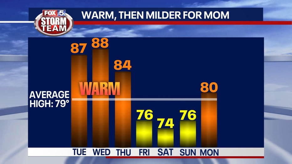
This favorable weather should hold through next Monday, promising a perfect Mother's Day on Sunday.
This is a developing weather system. Check back for updates and changes to the forecast as they become available.