

Tropical Depression 9 in Caribbean Sea forecast to become major hurricane that could threaten Florida
Tropical Depression Nine formed Friday morning in the Caribbean Sea, and much of the Florida Peninsula is already included in the cone of uncertainty for the system that's likely to become a major hurricane named Ian in the days ahead.
This tropical depression joins three other systems currently roaming the Atlantic Basin, including Hurricane Fiona, which will pummel Atlantic Canada this weekend, Tropical Storm Gaston near the Azores and Tropical Storm Hermine over the far eastern Atlantic.
While there's still a lot we don't know about the future of Tropical Depression Nine, here's everything the FOX Forecast Center can tell you right now ahead of this potential major-hurricane threat to the southeastern U.S. next week.
HOW TO WATCH FOX WEATHER ON TV
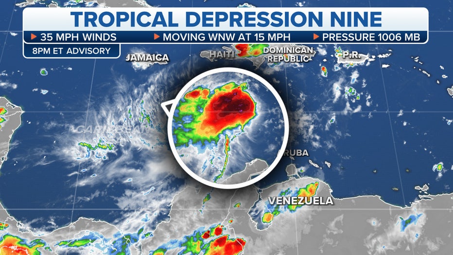
Where is Tropical Depression 9?
As of Friday evening, Tropical Depression Nine was in the central Caribbean Sea and centered around 400 miles southeast of Kingston, Jamaica, and about 700 miles away from the Cayman Islands.
The tropical depression had maximum sustained winds of about 35 mph and was moving west-northwestward at 15 mph.
Once this system's winds reach 39 mph or higher, it will become a tropical storm, and the National Hurricane Center will assign it the next name on this year's naming list, which would be Ian after the formation of Tropical Storm Hermine in the eastern Atlantic.
The Hurricane Hunters have several missions scheduled for Tropical Depression Nine to collect data that will be used to help meteorologists refine their forecasts.
TROPICAL DEPRESSION VS. TROPICAL STORM VS. HURRICANE: WHAT'S THE DIFFERENCE?
Tracking Tropical Depression Nine. (FOX Weather)
Where are alerts issued right now?
A Hurricane Watch has been issued for the Cayman Islands and a Tropical Storm Watch was in effect for Jamaica.
A Hurricane Watch means that hurricane conditions are possible within the alerted area. A watch is typically issued 48 hours before the anticipated first occurrence of tropical-storm-force winds, conditions that make outside preparations difficult or dangerous.
A Tropical Storm Watch means that tropical storm conditions are possible within the watch area, generally within 48 hours.
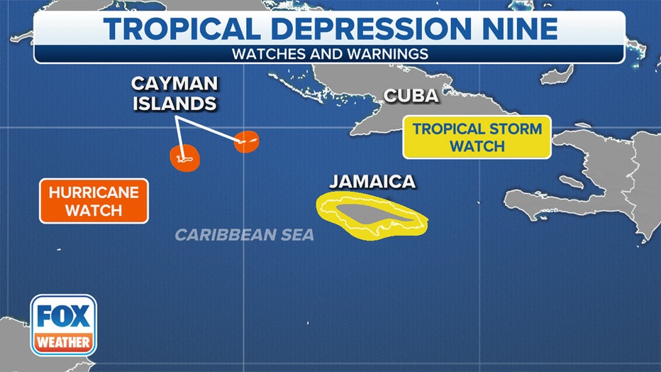
Weather alerts associated with Tropical Depression Nine. (FOX Weather)
What is the forecast for Tropical Depression 9?
Tropical Depression Nine is forecast to become a tropical storm by Saturday evening.
Only slow strengthening is forecast over the next day or two, but more significant intensification is expected on Sunday and Monday.
The current projection from the NHC shows this system becoming a hurricane in the northwestern Caribbean Sea either late this weekend or early next week as it approaches the Cayman Islands. Prior to that, it's forecast to pass south of Jamaica on Saturday night and Sunday as a strengthening tropical storm.
By next Tuesday or Wednesday, this likely hurricane is expected to be located somewhere between the eastern Gulf of Mexico and the general vicinity of the Florida Peninsula, possibly as a major hurricane – one that is rated Category 3 or stronger on the Saffir-Simpson Hurricane Wind Scale.
HOW ARE HURRICANES RATED? THE SAFFIR-SIMPSON HURRICANE WIND SCALE EXPLAINED
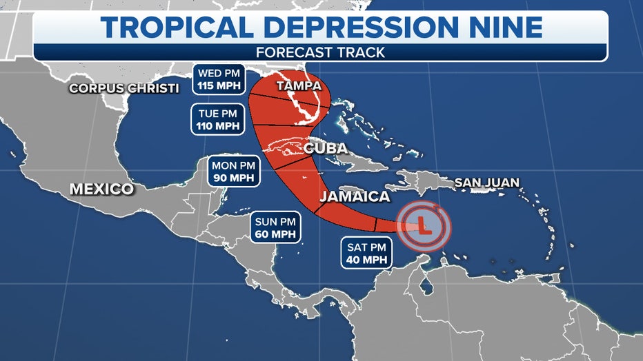
The projected path and intensity of Tropical Depression Nine. (FOX Weather)
"Now what you want to focus on is how big the cone really is. The skinnier the cone, the more confidence in the forecast. The larger the cone, the more questions there are as to where this storm is going to go," FOX Weather meteorologist Britta Merwin explained. "Obviously, on days 4 and 5 as it gets closer to Cuba and Florida, you see more of a spread, and that's something to really take note of. There are a lot of changes that are likely to happen in the later half of this forecast, and this entire area really needs to look out for the potential of where we could be seeing this system as we get into early next week."
WHAT IS THE ‘CONE OF UNCERTAINTY' IN HURRICANE FORECASTS?
Tropical Depression Nine is still battling wind shear – winds that change direction and speed at various heights – which is keeping thunderstorms associated with the system from growing, and that's expected to continue through Friday.
However, the NHC determined the system had at least become organized enough to be declared a tropical depression Friday morning.
According to the FOX Forecast Center, Tropical Depression Nine is expected to move into an area of the Caribbean Sea containing much lower wind shear and an abundant supply of deep, warm waters over the weekend.
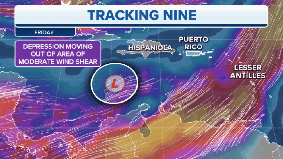
Tropical Depression Nine will move into an area containing much lower wind shear this weekend. (FOX Weather)
Water temperatures in this part of the Caribbean Sea are in the upper 80s, which is a couple of degrees above average, providing ample fuel for this system to intensify over the coming days.
However, one inhibiting factor could be land interaction with Cuba early next week before it reaches the Gulf of Mexico toward the middle of the week.
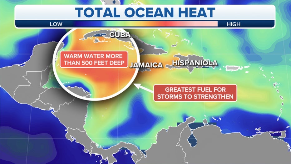
Tropical Depression Nine will move into an area containing an abundant supply of deep, warm waters. (FOX Weather)
What are the expected impacts of Tropical Depression 9 in the Caribbean?
The main concern from Tropical Depression Nine is heavy rainfall for Jamaica, the Cayman Islands, western and central Cuba, southern Haiti and the southern Dominican Republic beginning as soon as this weekend, according to the FOX Forecast Center.
The highest rainfall amounts are predicted in western and central Cuba, where 6 to 10 inches is expected with isolated amounts up to 14 inches. Jamaica and the Cayman Islands could see 4 to 8 inches of rain, with localized amounts up to 12 inches.
In southern Haiti and the southern Dominican Republic, between 2 and 4 inches of rain is forecast, though locally higher totals as high as 6 inches are possible.
Depending on the exact track and intensity of Tropical Depression Nine, there could also be tropical-storm-force (39-plus mph) or hurricane-force (74-plus mph) winds in these areas.
HERE ARE THE BUZZWORDS YOU'LL BE HEARING DURING HURRICANE SEASON
What threat will Tropical Depression 9 pose to Florida and the US Gulf Coast?
Tropical Depression Nine is predicted to be steered in the general direction of the eastern Gulf of Mexico and could be near the Florida Peninsula by the middle of next week.
An overwhelming majority of computer forecast models suggest the storm will likely be a major hurricane as it tracks toward the mainland U.S.
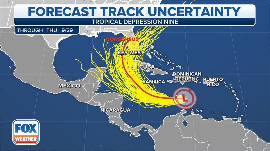
Each yellow line on the map depicts a different computer forecast model solution. (FOX Weather)
However, forecasts for newly developed tropical cyclones are challenging, so don't be surprised if the forecast for Tropical Depression Nine undergoes several changes – some of which could be significant – over the coming days.
The storm-track guidance from the various computer forecast models currently ranges from the eastern Gulf of Mexico to near or off Florida's Atlantic coast, so everyone in this general zone should begin their preparations now in the event of a potential major-hurricane strike next week.
HOW TO PREPARE FOR A HURRICANE
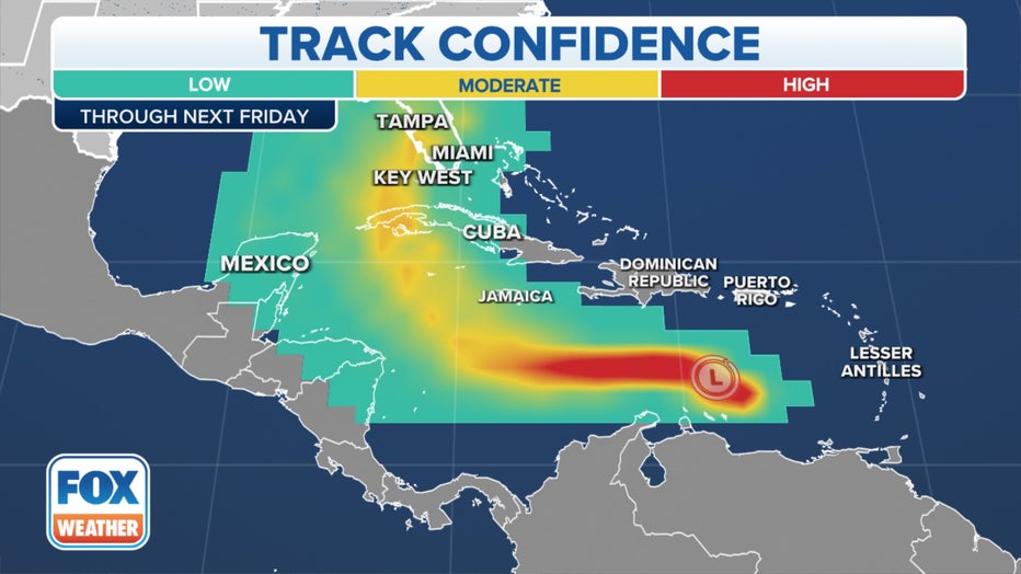
The various colors on the map indicate the confidence level in the track of Tropical Depression Nine. (FOX Weather)
So the bottom line is that it's still too early to know exactly where this system is heading, but know that there is a growing threat of a major hurricane impacting the southeastern U.S. around the middle of next week.
Florida Gov. Ron DeSantis declared a state of emergency for 24 counties that may be in the eventual path of Tropical Depression Nine, saying Floridians should prepare for the coming storm now. Residents can check their evacuation zone by typing in their address into an interactive map.
The FOX Forecast Center will be keeping a close eye on this system as it strengthens and tracks across the Caribbean in the days ahead.