

Rain moves out of North Georgia, drying out process begins
Thursday midday weather forecast
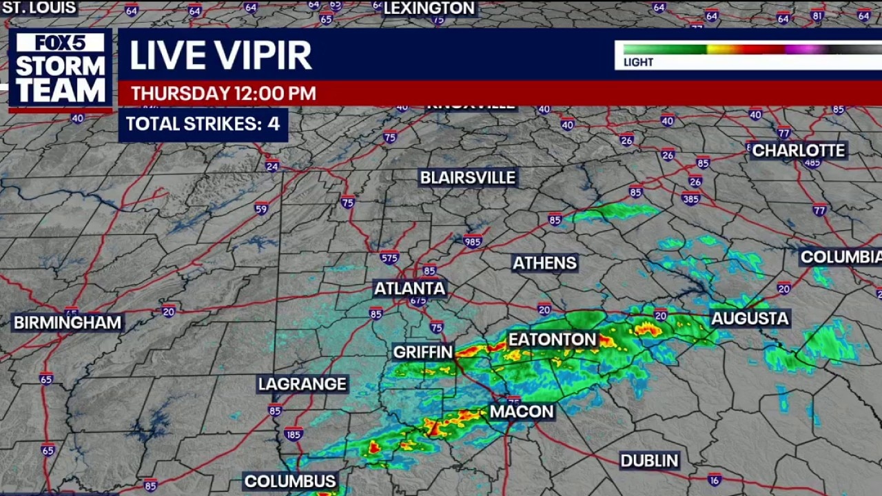
The majority of the heavier rain is now south of metro Atlanta and North Georgia is clearing up. Temps expected in the 70s for the rest of the day.
ATLANTA - North Georgia began drying out Thursday afternoon after strong overnight storms brought soaking rain across much of the area.
FOX 5 Storm Team meteorologist Greg Majewski said at noon Thursday that the remainder of the rain was falling south of metro Atlanta, stretching from Eatonton to Griffin and Barnesville, while North Georgia was expected to gradually clear through the rest of the day.
Rainfall totals across parts of north and central Georgia ranged between 2 and 3 inches, with some areas receiving lighter amounts under an inch. The rain provided much-needed drought relief after the latest drought monitor update was released Thursday.
Temperatures were expected to remain in the 60s and 70s Thursday afternoon with breezy conditions developing as the storm system moved out of the state. High pressure is expected to build in from the west, bringing drier and more pleasant weather Friday.
According to FOX 5 Atlanta Storm Team, the weekend will not be a washout, but more rain chances are expected to return for Mother’s Day weekend.
Driving conditions Thursday morning
What we know:
Drivers were advised to allow extra drive time because of standing water and the possibility of hydroplaning after widespread rainfall over the past 24 hours. Temperatures were sitting around 68 degrees early Thursday morning, with cooler conditions expected through the afternoon.
The rain was badly needed because of ongoing drought conditions, but the latest rainfall will not immediately appear on this week’s U.S. Drought Monitor report because data collection ended Tuesday. The impacts from this storm system are expected to show up in next week’s report.

Messy Thursday morning commute
The overnight rain and continuing rain on Thursday morning has resulted in a messy morning commute for drivers in metro Atlanta and North Georgia. Drivers are advised to use caution and be aware of possible ponding on the roadways.
Threat of severe weather over
What we know:
While tornado watches remained in effect through most of the morning for parts of South Georgia and the Florida Panhandle, North Georgia was mainly expected to see scattered showers and a few isolated thunderstorms through the morning hours.
The heaviest rain Thursday morning was expected in parts of southern metro Atlanta and areas near Covington as the storm system pushed northeast. Showers and storms were predicted to move out around midday, followed by gradual clearing and afternoon highs in the mid-70s. Overnight temperatures are expected to drop into the 50s.
Flood watches remained in effect through Thursday morning because dry, drought-stricken ground may not be able to absorb heavy rainfall quickly enough, increasing the risk of rapidly rising water in low-lying areas.
Click here for detailed Flood Watch information.

Storm brings down tree in Sandy Springs
The overnight storm that moved through metro Atlanta and North Georgia brought down a large tree in Sandy Springs. Marc Teichner reporting.
PREVIOUS UPDATES
1:30 a.m. — A strong thunderstorm over Upatoi is moving east at 55 mph, bringing 40 mph wind gusts, pea-sized hail, and heavy rain to northwestern Marion, northeastern Muscogee, northeastern Chattahoochee, southern Talbot, and southeastern Harris counties through 2:00 AM. Residents in areas like Talbotton and Waverly Hall should seek shelter immediately to avoid lightning and minor wind damage.
1:06 a.m. — A strong thunderstorm over Smiths Station is moving east at 45 mph, bringing 40 mph wind gusts, frequent lightning, and heavy rain to Muscogee, southwestern Talbot, and southern Harris counties through 1:30 AM. Residents in areas like Columbus and Waverly Hall should seek shelter immediately and motorists should be alert for possible hydroplaning
12:45 a.m. — The National Weather Service has canceled the Tornado Watch for metro Atlanta and most of North Georgia. The Flood Watch remains in effect though the morning.
10:47 p.m. — A strong thunderstorm over Sharpsburg is moving east at 50 mph, bringing 40 to 50 mph wind gusts, pea-sized hail, and frequent lightning to Fayette, Clayton, eastern Coweta, northwestern Spalding, and southwestern Henry counties through 11:15 p.m. Residents in areas like Newnan, Griffin, and Peachtree City should seek shelter immediately to avoid lightning and minor wind damage, keeping in mind that a Tornado Watch remains active.
10:30 p.m. — Several counties in extreme North Georgia have been removed from the Tornado Watch.
10:20 p.m. — A strong thunderstorm near Louvale is moving east at 55 mph, bringing 40 mph wind gusts, pea-sized hail, and frequent lightning to portions of Macon, Schley, Chattahoochee, Stewart, Sumter, Marion, and Webster counties through 10:45 p.m. Residents in areas like Americus and Buena Vista should seek shelter immediately to avoid lightning and minor wind damage, keeping in mind that a Tornado Watch remains active
10 p.m. - The FOX 5 Storm Teamis tracking an increase in rain and thunderstorms across North and Central Georgia, including the Atlanta area, as we head into the night. While it may seem quiet right now, the same weather system AND environment that caused severe storms in Alabama earlier today are moving into Georgia. This means the risk for severe weather, including the potential for a tornado, will continue through the overnight hours.
Storms roll into North Georgia; weather hampers air travel
The FOX 5 team is tracking the potential for severe weather as it rolls into North Georgia on Wednesday night. The area is seeing storms affect air travel.
9:43 p.m. — A strong thunderstorm over Hatchechubbe is moving east at 40 mph, bringing 40 mph wind gusts, pea-sized hail, and frequent lightning to southwestern Muscogee, southwestern Chattahoochee, and western Stewart counties through 10:15 p.m. Residents in areas like Cusseta and Fort Benning should seek shelter immediately to avoid lightning and minor wind damage, keeping in mind that a Tornado Watch remains active.
9:39 p.m. — Strong thunderstorms along a line from near Griffen Mill to Guerryton are moving east at 40 mph, bringing 40 mph wind gusts and pea-sized hail to Russell, southeastern Lee, east central Bullock, and northeastern Barbour counties through 10:15 p.m.. Residents in areas like Phenix City and Fort Mitchell should consider seeking shelter indoors to avoid gusty winds and minor hail, keeping in mind that a Tornado Watch remains active.
9:23 p.m. — A strong thunderstorm near Hillabee Creek is moving east at 55 mph, bringing 40 mph wind gusts and penny-sized hail to northern Tallapoosa, southeastern Clay, southwestern Randolph, and northwestern Chambers counties through 10 p.m. Residents in areas like Alexander City and Wadley should consider seeking shelter indoors to avoid gusty winds and minor hail, keeping in mind that a Tornado Watch remains active.
8:03 p.m. — A Severe Thunderstorm Warning has been issued for eastern Lumpkin, White, and northeastern Hall counties until 8:45 p.m. as a storm over Dahlonega moves east at 40 mph with 60 mph wind gusts and nickel-sized hail. Residents in areas like Cleveland and Clermont should move to an interior room on the lowest floor for protection, keeping in mind that a Tornado Watch remains active.
7:52 p.m. — A Severe Thunderstorm Warning has been issued for Habersham, northern Stephens, southwestern Rabun, and Oconee counties until 9 p.m. as a storm over Unicoi State Park moves east at 55 mph with 60 mph wind gusts and quarter-sized hail. Residents in areas like Seneca, Clarkesville, and Tallulah Falls should move to an interior room on the lowest floor for protection, keeping in mind that a Tornado Watch remains active.
7:39 p.m. — A severe thunderstorm over Cartecay is moving east at 55 mph, bringing 60 mph wind gusts and nickel-sized hail to Lumpkin, southeastern Gilmer, northwestern Dawson, northeastern Pickens, southwestern Union, and southeastern Fannin counties through 8:15 p.m. Residents in areas like Dahlonega and Amicalola Falls State Park should move to an interior room on the lowest floor to protect against potential damage to roofs, siding, and trees.
7:33 p.m. — A severe thunderstorm near Gaddistown is moving east at 55 mph, threatening White, central Union, southeastern Towns, and northeastern Lumpkin counties with 60 mph wind gusts and nickel-sized hail through 8 p.m. Residents in locations such as Cleveland, Blairsville, and Helen should move to an interior room on the lowest floor for protection against potential damage to roofs, siding, and trees.
7:31 p.m. — A strong thunderstorm over Talona is moving east at 55 mph, bringing 40 to 50 mph wind gusts, pea-sized hail, and frequent lightning to southern Gilmer, northwestern Dawson, and northeastern Pickens counties through 7:45 p.m. Residents in impacted areas like East Ellijay and Cartecay should seek shelter immediately to avoid lightning and minor wind damage, keeping in mind that a Tornado Watch remains active
7:20 p.m. — A severe thunderstorm near Rutherford is moving east at 40 mph, bringing 60 mph wind gusts and quarter-sized hail to southern Chattahoochee and Stewart counties through 8 p.m. Residents in areas like Lumpkin, Cusseta, and Richland should move to an interior room on the lowest floor to protect against hail and wind damage, keeping in mind that a Tornado Watch remains active
7:18 p.m. — A strong thunderstorm near Carters is moving east at 55 mph, bringing 40 to 50 mph wind gusts, pea-sized hail, and frequent lightning to southwestern Gilmer, southeastern Murray, and northeastern Gordon counties through 7:30 p.m. Residents in areas like Ellijay and Oakman should seek shelter immediately to avoid lightning and minor wind damage, keeping in mind that a Tornado Watch remains active
7:09 p.m. — A severe thunderstorm near Ellijay is moving east at 55 mph, threatening central Gilmer, southwestern Union, and eastern Fannin counties with 60 mph wind gusts and nickel-sized hail through 7:45 p.m. Residents in locations such as Blue Ridge and Morganton should move to an interior room on the lowest floor for protection, noting that a Tornado Watch remains
6:48 p.m. — A strong thunderstorm near Chatsworth is moving east at 55 mph, bringing 40 mph wind gusts, pea-sized hail, and frequent lightning to Gilmer, Murray, Whitfield, and Fannin counties through 7:15 p.m. Residents in impacted areas like Dalton and Blue Ridge should seek shelter immediately to avoid lightning and minor wind damage, keeping in mind that a Tornado Watch remains active until 2 p.m.
Storms and flooding take aim at North Georgia
What we know:
A slow-moving cold front pushed into a warm, humid airmass, creating the perfect recipe for multiple rounds of storms across North and Central Georgia. Most of the region was under a Slight Risk (Level 2 of 5) for severe weather.
The biggest concern for many was the Flood Watch, in effect from Wednesday afternoon through Thursday morning. Forecasters expect a widespread 1.5 to 2.5 inches of rain, though some spots could see more than 4 inches where storms repeatedly "train" over the same areas.
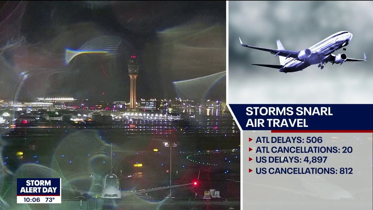
The thunderstorms disrupted travel at the world's busiest airport on Wednesday night. A ground stop at Hartsfield-Jackson Atlanta International Airport was issued around 7:30 p.m. causing delays of up to a half hour.

The following watches were in place late Wednesday:
- Flood Watch: Barrow, Bartow, Carroll, Catoosa, Chattooga, Cherokee, Cobb, Dade, Dawson, DeKalb, Douglas, Fannin, Fayette, Floyd, Forsyth, Gilmer, Gordon, Gwinnett, Hall, Haralson, Jackson, Lumpkin, Murray, Paulding, Pickens, Polk, Towns, Union, Walker, Walton, White, Whitfield Butts, Clayton, Coweta, Henry, Jasper, Lamar, Meriwether, Newton, North Fulton, Pike, Rockdale, South Fulton, Spalding, Upson.
- Tornado Watch: Banks, Butts, Chattahoochee, Harris, Lamar, Lee, Madison, Marion, Meriwether, Muscogee, Oglethorpe, Pike, Quitman, Randolph, Schley, Stewart, Sumter, Talbot, Taylor, Terrell, Troup, Upson, and Webster until 2 a.m.
Tracking the storm arrival
Timeline:
Multiple waves of rain and storms impacted the region, with the most active weather arriving Wednesday evening and lasting through the morning commute.
- Thursday Morning: The heaviest rain may hit the heart of the Metro during the morning commute before clearing out by midday.
Why the atmosphere is shifting
Big picture view:
The "why" behind this active stretch is a slow-moving frontal boundary interacting with a very moist airmass. This front is acting like a conveyor belt, bringing a "train of moisture" from the west across the Peach State. While early morning clouds might limit how much energy the storms have to work with, the sheer force of the winds high in the sky is enough to keep the threat of damaging winds and tornadoes on the table.
Mountain rain and metro totals
Local perspective:
The higher elevations of North Georgia, specifically the mountains, are at the highest risk for flash flooding. While the metro area will see significant rain, the steep terrain in the mountains can cause water to rise much more rapidly in creeks and streams. Regional totals are expected to be highest along and north of the I-85 corridor.
High water and heavy winds
Why you should care:
This weather event has the potential to impact your daily routine, especially travel.
- Travel: Expect hazardous driving conditions tonight and a potentially very wet, slow commute on Thursday morning.
- Safety: Flash flooding can happen quickly in urban areas and poor-drainage spots.
- Home: Ensure patio furniture is secure and storm drains near your home are clear of debris to prevent local ponding.
Looking ahead at the 7-day
By the numbers:
Metro Atlanta 7-Day Forecast:
- Wednesday: 83°F / Showers and storms likely (100% tonight)
- Thursday: 76°F / 60% chance of morning rain, then clearing
- Friday: 69°F / Mostly sunny
- Saturday: 74°F / Mostly sunny, slight chance of a shower
- Sunday: 76°F / 60% chance of showers
- Monday: 69°F / 30% chance of showers
- Tuesday: 71°F / Sunny
North Georgia 7-Day Forecast:
- Wednesday: 71°F / Showers and heavy rain
- Thursday: 70°F / 30% chance of showers, then partly sunny
- Friday: 69°F / Mostly sunny
- Saturday: 74°F / Mostly sunny
- Sunday: 76°F / Showers likely
- Monday: 69°F / 30% chance of showers
- Tuesday: 71°F / Sunny
The storm clears out
What's next:
Once the front clears the area on Thursday morning, we can "put all worries aside" for problematic weather for a few days. Drier, cooler air will move in for Friday, providing a much-needed break before another smaller chance of rain returns late in the weekend.