

Storms hit North Georgia Tuesday night

GEORGIA - A severe storm threat is possible through late Tuesday evening. Some storms have already caused damage, and stir up social media over a cloud outside Truist Park.
Damage around North Georgia
What we know:
A tree fell across two cars in DeKalb County. Nobody was injured, but both cars were heavily damaged.
Social buzz over a cloud
What they're saying:
Several people posted on social media and emailed the FOX 5 Storm Team on Tuesday night over a cloud seen outside Truist Park.
People thought it might be a tornado or funnel cloud, but it was not. It was a scud cloud.
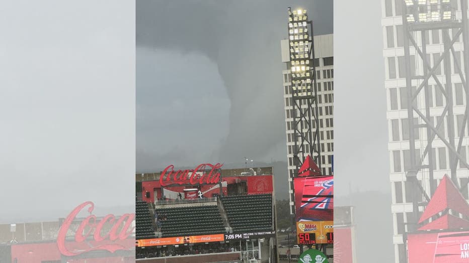
A scud cloud outside Truist Park on July 1, 2025. Picture courtesy of Melody Nolan.
Storms in Georgia on Tuesday
Timeline:
Here are the latest weather headlines:
9:39 p.m. - The National Weather Service issues a flash flood warning for Habersham County until 12:30 a.m. on Wednesday.
6:16 p.m. - The National Weather Service issued a severe thunderstorm warning for parts of Meriwether and Troup counties. The warning expired at 6:45p.m. Tuesday.
6:03 p.m. - The National Weather Service issued a severe thunderstorm warning for parts of Butts, Henry, Jasper and Newton counties. The warning expired at 6:30 p.m. Tuesday.
5:45 p.m. - The FOX 5 Storm Team tracked a strong storm near Athens, Ga. Temperatures dropped in the Classic City as the storms moved through.
4:08 p.m. - The FOX 5 Storm Team is tracking multiple storms moving across the state.
2:00 p.m. - Stone Mountain Park canceled its drone show due to the forecasted bad weather. The park said tickets for July 1 will be accepted any night through July 7. The park closed at 7 due to the forecast.
Tuesday night forecast
What we know:
All of North and Central Georgia are under a level 1 risk of severe weather.
Chief Meteorologist David Chandley said storms will be most likely in the afternoon and evening hours ahead of a weakening cold front.
"Any thunderstorms that develop will be capable of damaging winds to 60 mph and brief heavy rain," Chandley said.

Tuesday Night Weather Update
Scattered showers and storms into the evening, a few storms capable of damaging winds and brief heavy rainfall. Storms ending by midnight with fog forming toward morning. Wednesday will be sunny and dry. Hotter for the Weekend. Here is the breakdown.
The storms are not expected to be continuous or long-lasting, but most of the area could see storms.
You can see the latest radar here.
Flood threat
What's next:
With as much rain as the area has gotten recently, any heavy rain could lead to flooding.
The storm threat diminishes after midnight, according to the FOX 5 Storm Team.
Fog Wednesday morning
What's next:
Wednesday morning will bring fog to the area.
July 4th looks better
Dig deeper:
The Fourth of July forecast looks dry and hot.
The Source: Information for this article came from the FOX 5 Storm Team's forecast.