

This is why the Downtown Connector flooded during rush hour
Atlanta flash flood submerges Downtown Connector
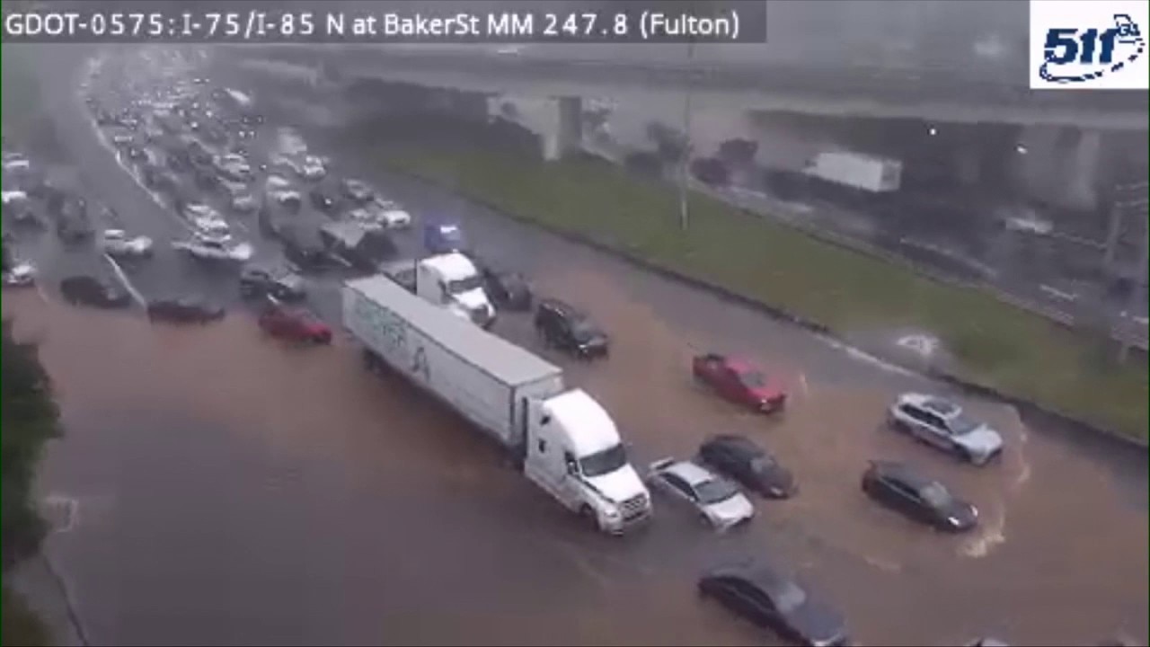
All northbound lanes of the Downtown Connector at the Baker Street overpass have reopened after heavy afternoon rainfall and debris-clogged storm drains left multiple vehicles submerged and paralyzed the rush hour commute, according to police.
ATLANTA - Flash flooding stranded multiple motorists on the Downtown Connector on Wednesday afternoon during the peak rush hour commute, forcing state troopers to shut down the highway.
Interstate flash flooding
What we know:
The Georgia Department of Transportation monitored traffic cameras that showed vehicles attempting to drive through deep floodwaters along Interstate 75 at Baker Street. The water quickly became too high for vehicles to pass, leaving several drivers stranded in the middle of the highway near the Baker Street overpass.
Rising floodwaters in Atlanta cause commuting nightmare
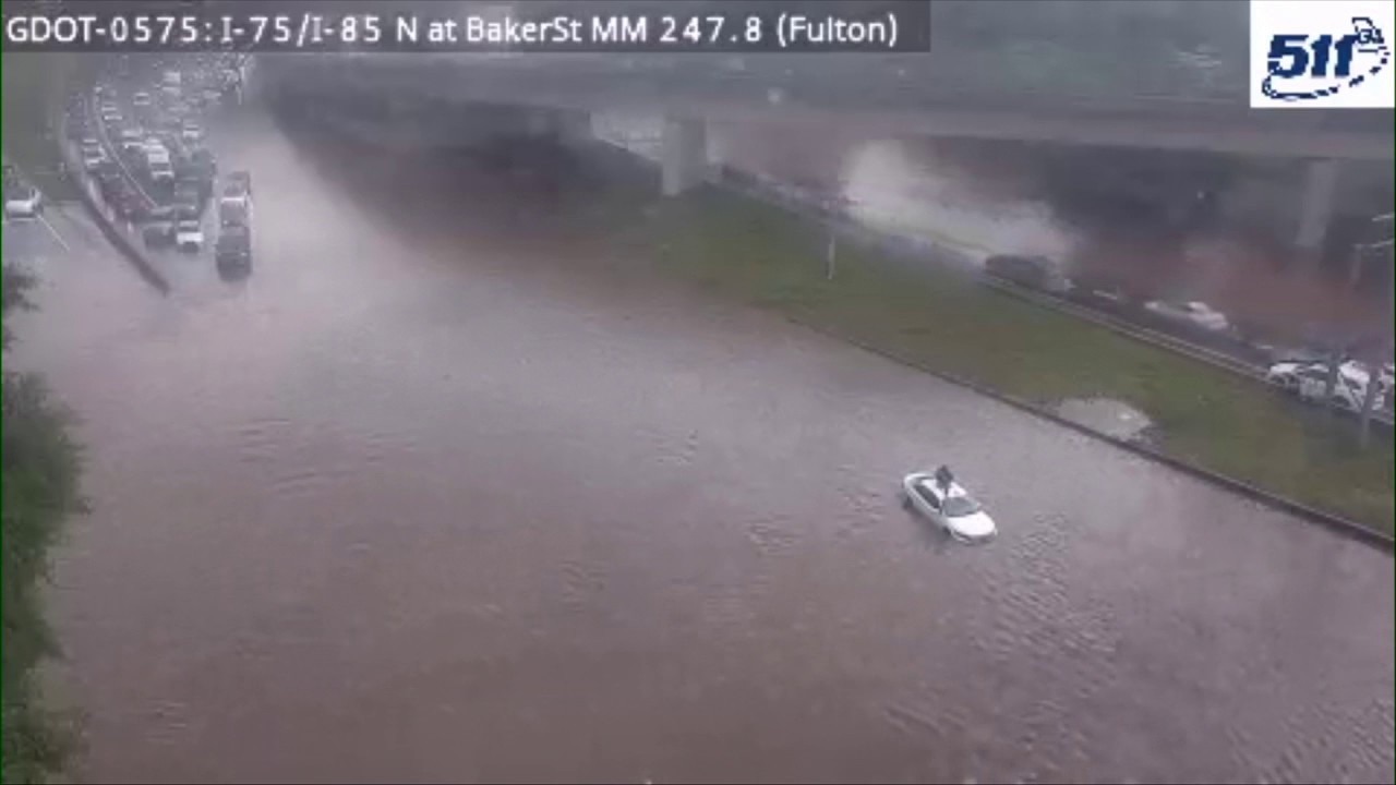
This video from a Georgia Department of Transportation camera along the Downtown Connector near Baker Street shows cars attempting to cross rising floodwater during the afternoon commute on May 20, 2026.
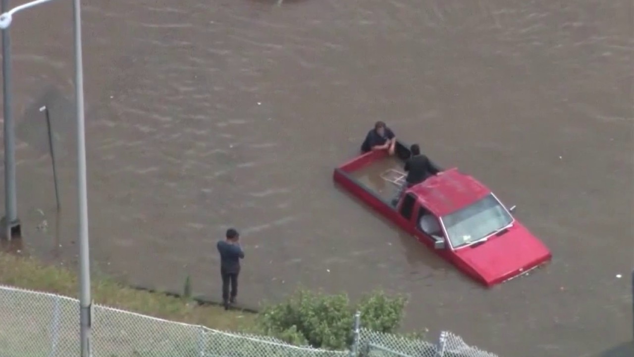
The water rose within a span of two minutes, leaving one vehicle partially submerged up to the window level. Video showed one person seeking refuge by standing on the roof of a white car surrounded by rising floodwaters before someone walked through the water to bring them to safety. Traffic was completely blocked from 5 p.m. until just before 6:30 p.m. while state troopers worked the scene.
Driver of stranded car rescued from floodwater
This GDOT video shows a driver being rescued from the roof of their car and escorted to the side the Downtown Connector near Baker Street on May 20, 2026.
According to the Atlanta Fire Rescue Department, emergency crews responded to the Downtown Connector near West Peachtree Street NE for reports of multiple stranded vehicles. Firefighters encountered four impacted vehicles but confirmed that all occupants had safely exited before crews arrived. Firefighters assessed the conditions, confirmed no water rescues were needed, and monitored the scene. No injuries were reported, and the highway was eventually reopened.
A Waymo autonomous vehicle was seen driving into a flooded street. The company issued the following statement in response:
"Safety is Waymo’s top priority, both for our riders and everyone we share the road with. During a period of intense rain today in Atlanta, an unoccupied Waymo vehicle encountered a flooded road and stopped. The vehicle has been recovered and removed from the scene."
While the vehicle was unoccupied, the company quickly paused service until the storms passed.
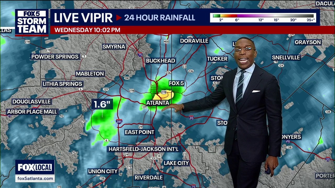
The National Weather Service placed Atlanta and nearby areas under a Flash Flood Warning until 11:15 p.m. Live radar indicated that between 1 and 1.5 inches of rain fell in a short period, with rainfall rates hitting 1 to 2 inches in 30 minutes. The National Weather Service officially canceled the flash flood warning at 8:15 p.m. after the storms moved out of the metro area.
The City of Atlanta released a statement noting that administration officials monitored the incident from the city's new Integrated Command Center. City teams actively monitored conditions, responded to affected areas, and coordinated across departments to address roadway hazards and drainage concerns. The city also collaborated with the Georgia Department of Transportation to monitor traffic impacts across the region and urged residents to report highway issues to state officials.
Storm drain blockages
Why you should care:
The flash flooding became severe because it followed weeks of completely dry weather across the city. The prolonged dry spell allowed leaves, natural debris, and everyday garbage to collect inside the drainage systems. When the heavy downpour hit the area, the accumulated debris completely blocked the runoff paths, leaving the heavy rainwater with nowhere to go.
The FOX 5 Storm Team tracked two slow-moving storm cells that lingered over downtown and Midtown Atlanta from the 3 p.m. hour into the 6 p.m. hour. Because the ground was dry, and the drains were covered in trash, the massive volume of water collected directly on the interstate lanes instead of draining away. Emergency officials warned that summer storms can develop rapidly and advised motorists to never risk driving through flooded roadways.
Regional weather impact
Timeline:
The severe weather began packing a punch early in the afternoon and tracking across multiple northern Georgia counties:
- 4:49 p.m.: A nearly stationary strong thunderstorm developed directly over West End Atlanta, impacting west-central DeKalb, south-central Cobb, east-central Douglas, and south-central Fulton counties.
- 5:10 p.m.: Heavy activity brought loud thunder to the west side of the city, prompting reminders for residents to head indoors immediately.
- 5:16 p.m.: Radar showed heavy rain totaling up to 1.5 inches falling across the warned areas, kicking off flash flooding.
- 5:32 p.m.: State traffic cameras captured rising water trapping cars at Baker Street, leading to a driver climbing onto a vehicle's roof.
- 5:50 p.m.: Motorists shared video online showing deep water completely covering Interstate 75/85 near North Peachtree Street.
- 5:52 p.m.: Officials issued a formal Flash Flood Warning for Atlanta, Midtown, Druid Hills, and surrounding neighborhoods.
- 6:10 p.m.: Atlanta Fire Rescue Department crews arrived on the Downtown Connector near West Peachtree Street NE to assess four flooded vehicles.
- 6:23 p.m.: Floodwaters began to slowly recede in the city center as the primary thunderstorm pushed away from the downtown grid.
- 6:25 p.m.: A strong thunderstorm moved over Commerce at 15 mph, bringing 40 mph wind gusts, heavy rain, and cloud-to-ground lightning to southeastern Banks, northeastern Jackson, and northwestern Madison counties through 7 p.m.
- 6:49 p.m.: A nearly stationary storm sat over Blairsville, bringing heavy rain, lightning, and 40 mph winds to northwestern Towns and northeastern Union counties.
- 6:54 p.m.: The storm tracked 5 miles southwest of Carnesville, moving northeast at 25 mph toward Franklin and southwestern Hart counties with half-inch hail threats.
- 7:15 p.m.: The City of Atlanta released an official statement detailing department coordination and emergency management responses.
- 8:15 p.m.: The National Weather Service officially canceled the flash flood warning for metro Atlanta.
Three inches of rain in one hour submerges Atlanta
Torrential downpours dumped up to three inches of rain in an hour, triggering flash flooding that trapped motorists in their vehicles on the Downtown Connector for over two hours during the afternoon commute, according to radar indications.
Flood totals
By the numbers:
- 3 inches: The maximum rainfall estimated by radar inside an hour's time across parts of Downtown and Midtown Atlanta.
- 1.5 inches: The rainfall total tracked between Campbellton Road and Cascade in the Ben Hill neighborhood.
- 1.5 inches: The approximate amount of rain that fell near the Stonecrest Mall area.
- 2 hours: The minimum amount of time that drivers spent trapped in their cars just north of the great curve on the highway connector.
Local community responses
What they're saying:
Georgia Tech professor Michel de Keersmaecker was traveling through the downtown area on a bicycle during the storm and observed the gridlock firsthand. "I didn't know what was happening," De Keersmaecker said. "And then I came here and I just passed by. And then I saw all this stuff. I've been going downtown area and, like, everything's just a mess. So I've been, like, trying to circle back on my bike, but it's been. It's been crazy."
City officials emphasized rapid deployment in their public briefing. "City teams are actively monitoring conditions, responding to affected areas, and coordinating across departments to address roadway hazards, drainage concerns, and any public safety needs," the administration said in a statement. "Residents are encouraged to avoid driving through standing water, use caution while traveling, and report non-emergency issues through ATL311."
Unresolved safety issues
What we don't know:
Officials have not confirmed exactly how many total vehicles sustained water damage or required towing from the Downtown Connector after the lanes reopened. It is also unclear how long it will take city sanitation crews to completely clear out the remaining debris from all the impacted storm drains across the downtown interstate system to prevent future flooding.
Highway navigation help
What you can do:
Drivers can monitor roadway conditions in real time by calling 511 before traveling on state routes and highways. The city advises using the ATL311 system to submit reports regarding non-emergency highway hazards or blocked drainage systems, while all immediate safety emergencies should be called into 911.
More rain on the way
What's next:
A separate weather wave lurking to the west will arrive on local doorsteps by Thursday. This incoming system threatens to cause significant travel problems for commuters during the Thursday afternoon drive.
The Source: The information in this story was gathered from the Atlanta Fire Rescue Department, who provided details on the stranded vehicles and emergency response, as well as the City of Atlanta and the National Weather Service. FOX 5's Rob DiRienzo interviewed several residents impacted by the flooding. This article has been updated since it was originally published.