

Strong storms move through metro Atlanta Thursday morning
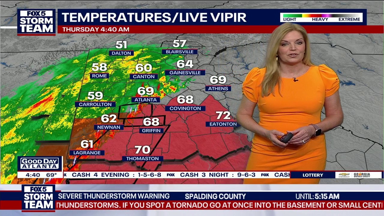
Early Thursday morning forecast
Thunderstorms are currently rolling through the metro Atlanta area. Heavy rain is being seen in multiple areas. Tornadoes are also possible.
ATLANTA - Residents across the south metro area woke up to a storm alert this Thursday morning as a powerful low-pressure system moved through the region, bringing a mix of severe thunderstorms, the possibility of tornadoes, and a dramatic drop in temperature.
Latest weather forecast & radar
The severe weather, which began ramping up around 4:30 a.m., triggered multiple warnings for several counties. The FOX 5 Atlanta Storm Team tracked the line of storms moving eastward that carries the risk of strong winds and isolated, quick-spinning tornadoes.
KEEP UP WITH THE LATEST BY DOWNLOADING THE FREE FOX 5 STORM TEAM APP AND FOLLOWING @FOX5STORMTEAM ON X, FORMERLY TWITTER
A Severe Thunderstorm Warning was in effect until 7:15 a.m. for Bibb, Jones, Monroe, Peach, Crawford, Jasper, Baldwin, Houston, Putnam, and Twiggs counties.
A Severe Thunderstorm Warning was in effect from 6:30 to 7:30 a.m. for Putnam, Jasper, Baldwin, Greene, Hancock, and Dougherty County. A warning is also in effect until 7 a.m. for Clay County.
Tornado warnings were also issued for several counties just south of the FOX 5 Atlanta viewing area. There have also been unconfirmed reports of brief touchdowns. At this time, no major damage has been reported.
While the most intense activity is expected to clear the state line by mid-morning, it will be replaced by a significant "weather whiplash." After tying a record high of 82°C yesterday, temperatures are forecasted to plummet to a high of just 58°C today, with some areas dipping near freezing by Friday morning.
Schools in Rockdale, Meriwether and Troup County Schools were on a two-hour delay on Thursday. Click here for closings.
Road conditions
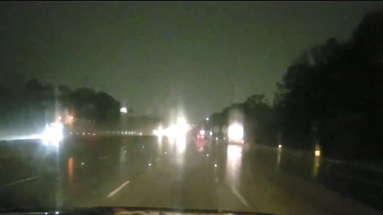
Several crashes were reportedly early Thursday morning in the metro Atlanta area. The morning began with a bottleneck on Interstate 285. A crash just past Chamblee Tucker Road cleared around 6 a.m. and while lanes have reopened, traffic was heavy through the area immediately following the crash.
Trouble was reported in DeKalb County on I-20 westbound just before Gresham Road that blocked the left lane.
FOLLOW SKYFOX TRAFFIC ON X FOR LATEST
There was also significant disruption in Cobb County. A crash on I-75 southbound at Belk Road resulted in the closure of two center lanes shortly after 6 a.m. Drivers were told to use Highway 41 as a bypass.
A police vehicle was also involved in a crash at Lavista and Montreal roads in DeKalb County. It is unknown if anyone was injured in the incident.

Cop car involved in DeKalb crash
A police car was involved in a crash in DeKalb County early Thursday morning. At this time, it is unknown if there were any injuries. This is a breaking news report.
Additionally, a school bus crashed on Clairmont Road in DeKalb County around 8 a.m.

School bus crash in DeKalb; road conditions
A school bus has crashed on Clairmont Road in DeKalb County. Additionally, flooding has been seen on several roads and interstates in the metro Atlanta area.
Other incidents:
With rain continuing until later this morning, drivers are urged to reduce speeds, maintain extra following distance, and turn on headlights.
Tracking severe weather on Atlanta roads
A thunderstorm is rolling through the metro Atlanta area, which is making the roads a mess. FOX 5 Atlanta is monitoring road conditions.
Tornado Watch issued
What we know:
The National Weather Service issued a Tornado Watch until 9 a.m. EDT for the following Georgia counties: Butts County, Newton County, Clay County, Dougherty County, Irwin County.
The National Weather Service issued a Tornado Watch effective until 8 a.m. EDT for the following Georgia counties:
Baker, Baldwin, Banks, Barrow, Bartow, Bibb, Bleckley, Butts, Calhoun, Carroll, Catoosa, Chattahoochee, Chattooga, Cherokee, Clarke, Clay, Clayton, Cobb, Coweta, Crawford, Crisp, Dade, Dawson, Decatur, DeKalb, Dodge, Dooly, Douglas, Dougherty, Early, Emanuel, Fannin, Fayette, Floyd, Forsyth, Gilmer, Glascock, Gordon, Greene, Gwinnett, Hall, Hancock, Haralson, Harris, Heard, Henry, Houston, Jackson, Jasper, Jefferson, Johnson, Jones, Lamar, Laurens, Lee, Lumpkin, Macon, Madison, Marion, Meriwether, Miller, Mitchell, Monroe, Montgomery, Morgan, Murray, Muscogee, Newton, North Fulton, Oconee, Oglethorpe, Paulding, Peach, Pickens, Pike, Polk, Pulaski, Putnam, Quitman, Randolph, Rockdale, Rome, Schley, Seminole, South Fulton, Spalding, Stewart, Sumter, Talbot, Taliaferro, Taylor, Telfair, Toombs, Towns, Treutlen, Troup, Turner, Twiggs, Union, Upson, Walker, Walton, Warren, Washington, Webster, Wheeler, White, Whitfield, Wilcox, Wilkes, Wilkinson, and Worth.
The FOX 5 Storm Team says the primary threats with these thunderstorms include damaging wind gusts, a brief spin-up tornado or two, and small hail. Frequent lightning and heavy rainfall are also expected through Thursday morning.
Not everyone will see storms during that entire time period, but the system will take several hours to move across the region.
In addition to the risk of strong storms, heavy rain could fall across parts of the region, potentially creating a wet Thursday morning commute.

‘During the darkness of night’
What they're saying:
The FOX 5 Storm Team is monitoring a shift in the severe weather outlook.
"The SPC tinkered with the severe outlook for tonight, slightly," said FOX 5 Storm Team Meteorologist Alex Forbes. "A Level 2 is in place for areas along a line and west of Carrollton to Thomaston. A Level 1 is in place for the rest of us. Still not expecting a crazy event. Watching for a sporadic wind gust of 60 mph and a brief spin-up tornado."
FOX 5 Storm Team Chief Meteorologist David Chandley expressed concern regarding the potential for "twisting with those cells" as the line approaches the metro area. While the metro region remains under a marginal risk, the greater threat for severe weather and potential tornadoes stays to the southwest.
The system is expected to bring beneficial rainfall, with projections ranging from half an inch to an inch in some areas. However, high winds remain a significant concern.
"The wind is going to be howling," as the front rolls through, switching from the southwest to the northwest. Gusts could exceed 30 mph by lunchtime Thursday, potentially threatening trees and power lines.
When are storms rolling in?
Timeline:
The FOX 5 Storm Team expects the following timing for the arrival of the storm line and subsequent clearing:
- Metro Atlanta: Activity is expected to peak between 4 a.m. and 9 a.m. Thursday.
- Central/East Georgia: The line will reach the Columbus and Macon areas around sunrise, lingering through the mid-morning hours.
- Thursday Afternoon: Rapid clearing from the northwest as much drier and colder air arrives.
Powerful cold front moves through
Big picture view:
The FOX 5 Storm Team attributes this weather event to a strong cold front supported by a shortwave traversing the northern Gulf. This setup provides enough shear to favor embedded spin-up tornadoes within the line. While instability is limited, it is sufficient to maintain a line of storms capable of producing damaging winds. Behind the front, a significant airmass change will occur as high pressure builds in for the weekend.
What can you expect overnight?
Local perspective:
Rainfall will be heavy at times, leading to localized flooding in low-lying areas. While snow and ice are not forecast with this system, the "temperature roller coaster" is the main local story. After seeing highs in the 80s on Wednesday, North Georgia will struggle to leave the 50s on Thursday afternoon.
What could happen with this front?
Why you should care:
The severe weather brings a high risk of downed trees and power lines, which could lead to scattered power outages during the morning peak. Travel hazards include reduced visibility from heavy rain and powerful wind gusts of 25 to 30 mph following the frontal passage. Furthermore, a significant freeze threat looms for the middle of next week, which could impact early spring vegetation.
7-day forecast
By the numbers:
Metro Atlanta 7-Day Forecast
- Wednesday Night: 80% chance of rain; Low 46.
- Thursday: 80% chance of rain; High 58 / Low 39.
- Friday: Sunny; High 65 / Low 45.
- Saturday: Sunny; High 76 / Low 54.
- Sunday: 30% chance of rain; High 75 / Low 49.
- Monday: 60% chance of rain; High 59 / Low 31.
- Tuesday: Mostly sunny; High 51 / Low 35.
North Georgia Mountains 7-Day Forecast
- Wednesday Night: 90% chance of rain; Low 39.
- Thursday: 80% chance of rain; High 52 / Low 31.
- Friday: Sunny; High 61 / Low 37.
- Saturday: Sunny; High 71 / Low 46.
- Sunday: 20% chance of rain; High 67 / Low 40.
- Monday: 80% chance of rain; High 53 / Low 22.
- Tuesday: Mostly sunny; High 45 / Low 26.
The weekend and week ahead
What's next:
The passing front will usher in a dramatic shift in temperature. After a record-tying Wednesday, Thursday will be notably cooler, with temperatures expected to be in the 40s by this time tomorrow.
- Friday Morning: Clear skies and sunshine will return, but morning lows will drop into the 30s before rebounding into the 50s and 60s by the afternoon.
- Next Week: A second "punch" of cold air is expected Sunday night. This will bring a "big time cold snap" for Monday, Tuesday, and Wednesday, with overnight lows dipping back down to the freezing mark.