

Memorial Day storms move into metro Atlanta bringing flood risk
Storms soak North Georgia on Memorial Day
Rounds of rain and thunderstorms are pelting North Georgia on Monday bringing a risk of possible localized flooding. Here's your latest forecast update.
ATLANTA - Metro Atlanta and North Georgia are facing an increasing flood threat Monday evening as a stronger and more organized round of heavy rain moves through the area, according to the FOX 5 Atlanta Storm Team.
What we know:
A heavy line of showers and storms is packing a punch across the region, bringing intense downpours and frequent lightning. Due to the high volume of water falling in a short period, a Flood Watch has been extended through Tuesday evening.
The main threat with these storms is excessive rainfall that could easily lead to flash flooding in areas with poor drainage. A flash flood warning is in effect until 1 a.m. on Tuesday for southeastern Madison County and western Oglethorpe County.
A flood warning is in effect for Big Creek near Alpharetta primarily impacting Forsyth and Fulton counties. An additional warning affects Big Creek at GA 9 near Cumming. Minor flooding is forecast to continue in these areas, according to the National Weather Service.
A downed tree was reported on E. Rock Springs Road.
Forecasters warned rainfall rates could reach up to 2 inches per hour in the heaviest storms, increasing the risk of flash flooding in poor drainage areas and flood-prone locations across North Georgia.
A flood watch remains in effect through late Monday evening for much of metro Atlanta and areas north and west of the city. Nearly all of North Georgia faces at least some risk for flash flooding if storms repeatedly move over the same areas.
Click here for latest weather alerts.
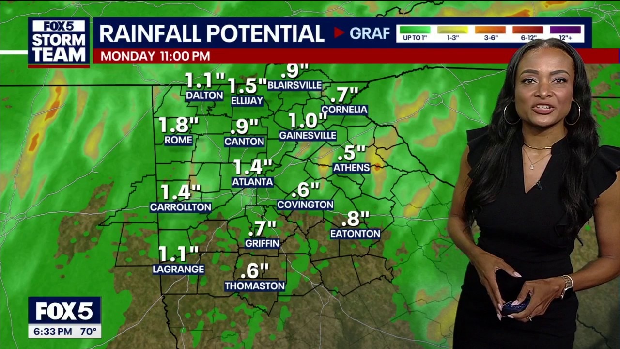
The latest update also highlights how uneven the rainfall has been across the region in recent days.
Some communities, including parts of Paulding County, Sandy Springs, East Cobb and Woodstock, have already received around 6 inches of rain, while other areas have seen significantly less precipitation.

The humidity remains extremely high, with dew points near 70 degrees across Atlanta, creating tropical-like conditions throughout the region.
Outdoor Memorial Day plans, graduations and cookouts are likely to be impacted by rounds of showers and storms through the evening. The FOX 5 Atlanta Storm Team says anyone planning outdoor activities should closely monitor radar conditions throughout the day.

The unsettled weather pattern is expected to continue Tuesday, although we now believe the rain may not be quite as intense or widespread as Monday’s storms. By Wednesday, rain chances are expected to gradually decrease, with fewer heavy downpours anticipated.
Rainfall totals will continue to vary dramatically from one neighborhood to another, with some areas receiving less than an inch of rain while others could pick up several inches over the next few days.

🌧️ Breakout forecast
⚠️ What changed since this morning
- Storm threat now expected to become more organized late today
- Heaviest rain expected during the evening commute
- Rainfall rates could now reach 2 inches per hour
- Flash flooding risk has increased across North Georgia
🌩️ Monday evening
- Line of storms moves into metro Atlanta after 4 p.m.
- Heavy rain and localized flooding possible
- Flood watch remains in effect
- Highs in the upper 70s
🚗 Travel concerns
- Ponding on roads possible during rush hour
- Flooding risk highest in low-lying and poor drainage areas
- Drivers urged to avoid flooded roadways
🌦️ Tuesday
- More scattered showers and storms
- Rain not expected to be as intense
- Continued cloudy and humid conditions
- Rain chance: 70%
☁️ Wednesday
- Fewer storms expected
- Rain coverage begins decreasing
- Still cloudy with scattered showers possible
☀️ Looking ahead
- Thursday expected to trend drier
- Best chance for a break in rain currently arrives next Sunday with rain chances dropping to 20%