

Severe Thunderstorm Watch issued across North Georgia on Thursday

Thursday night forecast
Some strong to severe thunderstorms are possible tonight and into early Friday morning; otherwise, it will be warm and muggy with morning temperatures in the 60s. There will be a mix of sun and clouds on Friday with a high near 80. Showers will return for the weekend. Here is the breakdown.
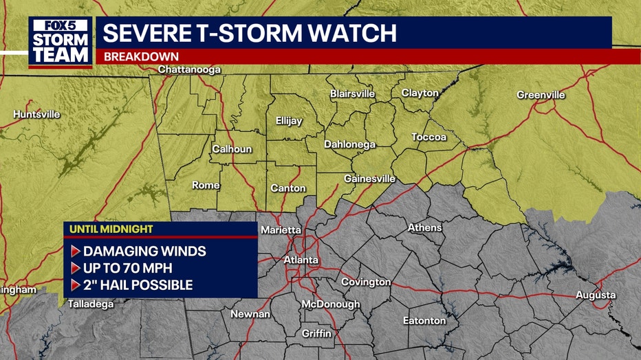
ATLANTA - A Severe Thunderstorm Watch has been issued for most of North Georgia through midnight.
The FOX 5 Storm Team is monitoring the threat of isolated severe storms.
What we know:
The watch area includes Banks, Towns, White, Cherokee, Dawson, Fannin, Forsyth, Gilmer, Hall, Lumpkin, Pickens, Bartow, Catoosa, Chattooga, Dade, Floyd, Gordon, Murray, Walker, Whitfield, and Union counties.
Local perspective:
Here is the latest:
10:59 p.m. - A strong thunderstorm will impact portions of northwestern Gilmer, northeastern Murray, northeastern Whitfield and northwestern Fannin counties through 11:30 p.m. At 10:59 p.m., a strong thunderstorm was over Beaverdale, or 9 miles north of Chatsworth, moving southeast at 30 mph. Hazards include 40 to 50 mph wind, up to penny sized hail and frequent cloud to ground lightning.
10:51 p.m. - A strong thunderstorm will impact portions of central Floyd, southwestern Gordon and central Chattooga Counties through 11:15 p.m. At 10:51 p.m., a strong thunderstorm was over Holland, or near Summerville, moving northeast at 25 mph. Hazards include 40 to 50 mph wind, nickel sized hail and frequent cloud to ground lightning.
10:27 p.m. - A Severe Thunderstorm Warning for west central Cherokee County in north central Georgia and central Bartow County in northwestern Georgia until 11:15 p.m. At 10:27 p.m., a severe thunderstorm was located over Cassville, or near Cartersville, moving east at 25 mph. Expect up to 60 mph wind gusts and quarter size hail.
10:20 p.m. - A strong thunderstorm will impact portions of northwestern Cherokee, east central Floyd, southeastern Gordon, southwestern Pickens and Bartow counties through 10:45 p.m. At 10:20 p.m., a strong thunderstorm was over Kingston, or 9 miles northwest of Cartersville, moving northeast at 35 mph. Expect up to 40 mph wind, pea sized hail and frequent cloud to
ground lightning.
10:15 p.m. - A strong thunderstorm will impact portions of Catoosa, northeastern Murray, northeastern Whitfield and northwestern Fannin counties through 10:45 p.m. At 1015 p.m., a strong thunderstorm was over Indian Springs, or near Ringgold, moving east at 40 mph. The storm could bring 40 to 50 mph wind, nickel sized hail and frequent cloud to ground lightning.
9:44 p.m. - A Severe Thunderstorm Warning for Northwestern Walker County until 10:30 p.m. FOX 5 Live VIPIR at 9:44 p.m., was tracking a severe thunderstorm was located over Stevenson, or 8 miles southwest of Bridgeport, moving northeast at 50 mph. Expect 60 mph wind gusts and quarter size hail with this storm.
9:42 p.m. - A strong thunderstorm will impact portions of central Floyd, southwestern Gordon and central Chattooga Counties through 1015 p.m. At 942 p.m., a strong thunderstorm was over Fullerton, or near Cedar Bluff, moving east at 30 mph. It can pack 40 to 50 mph wind, up to penny sized hail and frequent cloud to ground lightning.
9:23 p.m. - A strong thunderstorm will impact will impact portions of northwestern Walker and Dade Counties through 10 p.m. At 923 p.m., a strong thunderstorm was over South Pittsburg, or near Jasper, moving east at 30 mph. It packs 40 to 50 mph wind, up to penny sized hail and frequent cloud to ground lightning.
8:39 p.m. - A strong thunderstorm will impact portions of southwestern Walker and Chattooga counties through 9:15 p.m. FOX 5 Live VIPIR has been tracking a strum over Chesterfield, or 8 miles northeast of Little River Canyon National Preserve, moving northeast at 20 mph. The storm can produce 40 to 50 mph wind, penny sized hail, and frequent cloud to ground lightning.
6:11 p.m. - Strong thunderstorms are impacting Rabun County. FOX 5 Live VIPIR was tracking a strong thunderstorm 14 miles southeast of Franklin, or near Highlands. Another storm was located near Sky Valley Georgia. Both storms were moving east at 30 mph. Wind gusts of up to 40 mph and nickel size hail are possible.
5:25 p.m. - FOX 5 Live VIPIR has been tracking a strong thunderstorm about seven miles west of Clayton, or about five miles north of Lake Burton. It was heading east at 30 mph with the potential of dumping penny size hail and with wind gusts of up to 40 mph.
5 p.m. - A Severe Thunderstorm Warning was issued for eastern Cherokee County and northwestern Clay County in southwestern North Carolina until 5:45 p.m. According to FOX 5 Live VIPIR, a severe thunderstorm was located near Murphy, moving east at 20 mph. Winds with 60 mph gusts and half dollar size hail is possible.
KEEP UP WITH THE LATEST BY DOWNLOADING THE FREE FOX 5 STORM TEAM APP AND FOLLOWING @FOX5STORMTEAM ON X, FORMERLY TWITTER
What they're saying:
North and central Georgia residents could see strong storms Thursday night as a weather system currently affecting the Tennessee Valley and Kentucky moves south and east, according to FOX 5 Storm Team meteorologist Jonathan Stacey.
"This afternoon across the Tennessee Valley and up through Kentucky, you see just kind of a wide dispersal of storm cells," Stacey said. "Many of them are warned right now, meaning that they are likely producing damaging wind gusts in excess of 60 miles an hour, or potentially even dropping some hail."
That system is expected to gradually push into Georgia by sunset, bringing scattered thunderstorms, potentially severe, into the overnight hours.
Stacey said isolated showers had already formed near the South Carolina state line earlier in the day, but no lightning or thunder was associated with those early cells. "Around the metro area, no issues right now," he said. "So if you do need to get something done outside... no need to stop because the timing of today’s weather is really more sunset or post-sunset driven."
As the evening progresses, the threat of damaging winds and quarter-sized hail increases. "There will be thunder, lightning associated with these cells. There's a low, but still not a non-zero risk for tornadoes," Stacey added.
Timeline:
While early forecast models showed storms developing over the metro area by 5 p.m., Stacey said he wasn’t seeing signs of that yet. By 10 p.m., he said scattered storms were expected to break out mainly in East and Middle Georgia.
"Some neighborhoods will get some light showers, but there will be some cells that definitely grab our attention," Stacey said. "Those could end up being the severe cells as we get into the midnight period."
By around 2 a.m. Friday, severe weather could still linger with isolated storms — the "lone rangers" Stacey warned could still pack a punch.
"They're small but mighty," he said. "Just because everybody’s not getting it doesn’t mean that those who end up getting it are not getting the worst of it."
Dig deeper:
Wind gusts could reach up to 60 miles per hour overnight, especially in metro Atlanta and southward. "We could easily find gusts topping 40 miles an hour," Stacey said. "Once again, you could get up to 60 mile per hour gusts, which would of course be severe winds."

Thursday evening forecast
The FOX 5 Storm Team is tracking a severe storm threat through late evening hours. Here's the latest.
Friday morning is expected to bring calmer conditions, though some trees may be down from overnight storms. A brief dry spell is forecast before more rain returns Saturday.
"It’s more of a rain and cool event," Stacey said of Saturday’s forecast, with high temperatures remaining in the 60s. "Mother’s Day, looking slightly better but still damp, and we’ll keep that trend going until Wednesday."
This is a developing weather system. Check back for updates and changes to the forecast as they become available.
The Source: This article is based on original forecasting by the FOX 5 Storm Team.