

Level 2 storm threat across North Georgia on Wednesday
Metro Atlanta under level 2 severe risk Wednesday
Metro Atlanta is under a level 2 risk of severe weather Wednesday as storms move into the area.
ATLANTA - The risk for severe weather is rising across North Georgia, with all of metro Atlanta now upgraded to a Level 2 ahead of an approaching storm system.
Storms likely in North Georgia on Wednesday
What they're saying:
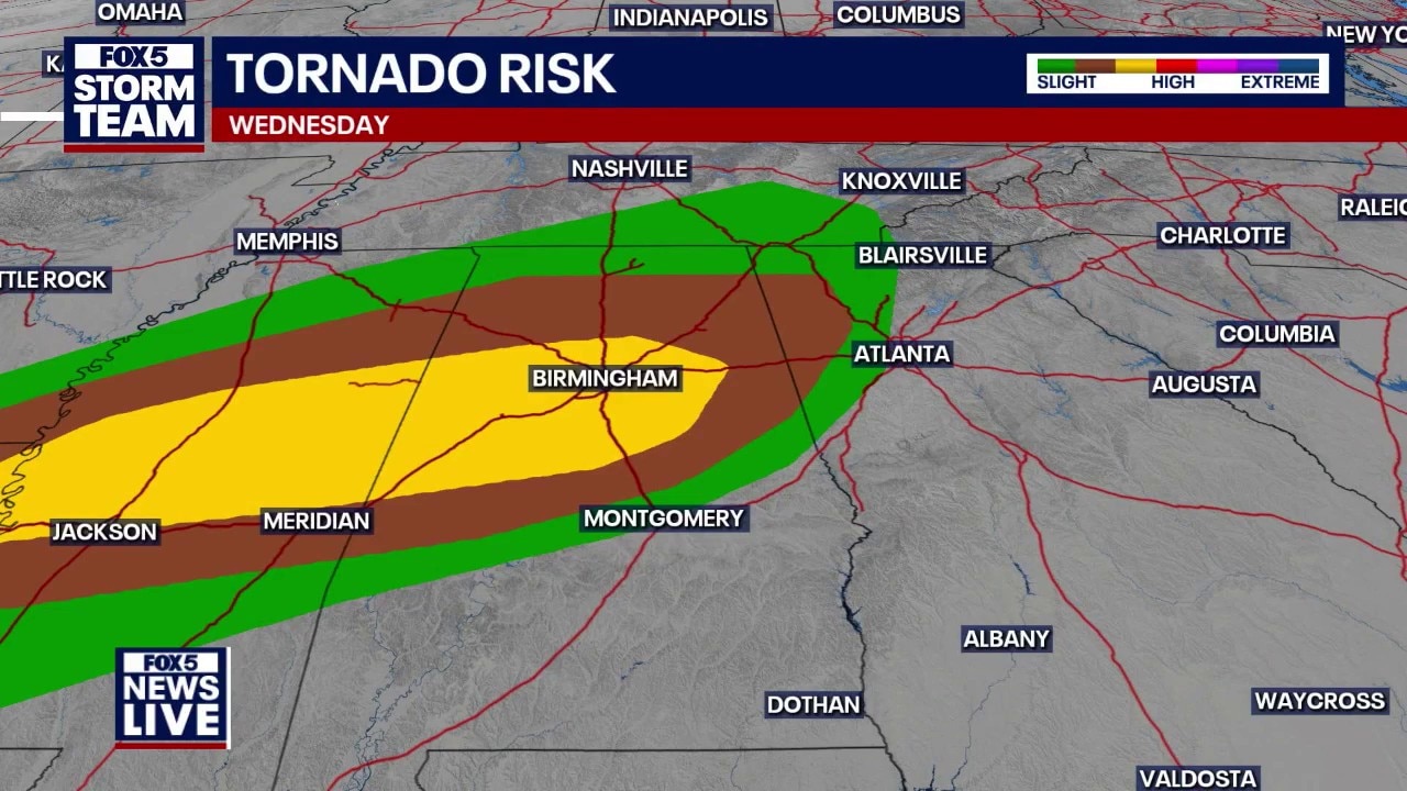
That Level 2 risk stretches from Calhoun to Dawsonville and Gainesville, and south through Eatonton, Griffin, and LaGrange, putting a large portion of north and central Georgia in the zone for stronger storms.
Within that broader risk area, one key change stands out — a slight increase in the tornado threat, especially across parts of northwest Georgia.
"What you’re going to notice is that tornado threat dragged a little further into parts of northwest Georgia," Forbes said. "Calhoun, Rome, Villa Rica, Carrollton — you’re a notch higher than you were earlier."
While the most intense storms are expected to stay to the west, Georgia will still feel impacts as the system moves through.
"Back into Alabama, that’s where the bigger storms are going to be," Forbes explained. "That’s where the focal point is. We’re going to be looking more at Mississippi and Alabama than in northwestern Georgia — but we’re not out of the woods."
Rain following Georgia drought
Local perspective:
In addition to the severe threat, heavy rainfall is expected, with totals of 2 to 3 inches possible in some areas.
"Given how dry the ground is, that could become a little problematic when it comes to flooding," Forbes said. "That’s something we’ll be keeping an eye on."
Timing North Georgia storms
Timeline:
Most of Wednesday daytime will stay dry, though a few isolated storms could develop by late morning or afternoon. The more widespread activity arrives later.
"Don’t sleep on this," Feldman said. "These can still be very strong storms even if they only affect a few areas Wednesday."
The main line of storms is expected Wednesday evening, potentially reaching metro Atlanta around 8 p.m. before continuing overnight.
"If this model holds true, the main severe weather threat would be late in the evening," Feldman said. "The severe storm threat would taper off overnight, but the rain not necessarily."
Scattered showers and storms may linger into Thursday morning before drying out later in the day.
Temperatures will remain warm ahead of the system, with highs near 80 degrees today and Wednesday.

Morning lows will also trend milder, starting in the 60s Wednesday.
Cooler air follows storms
What's next:
Behind the front, cooler air moves in.
"In the days to come, it’s an unsettled pattern — but that’s exactly what we need," Forbes said. "We don’t need a lot of rain at once, even though we might see that tomorrow. Keeping this trend alive is progress for the drought situation as we head into mid-May."
Rain chances return again this weekend and into early next week, keeping the unsettled pattern going.
The Source: This article was written by the FOX 5 Atlanta Digital Team based off the FOX 5 Storm Team forecast.