

Atlanta weather: Flood watch remains as severe storms move out
Thursday night forecast
A relentless wave of severe weather fueled by tropical remnants slammed north Georgia on Thursday, leaving a trail of road flooding and high winds across major metro corridors.
ATLANTA - A relentless wave of severe weather fueled by tropical remnants slammed North Georgia on Thursday, leaving a trail of road flooding and high winds across major metro corridors.
Georgia flash flooding
What we know:
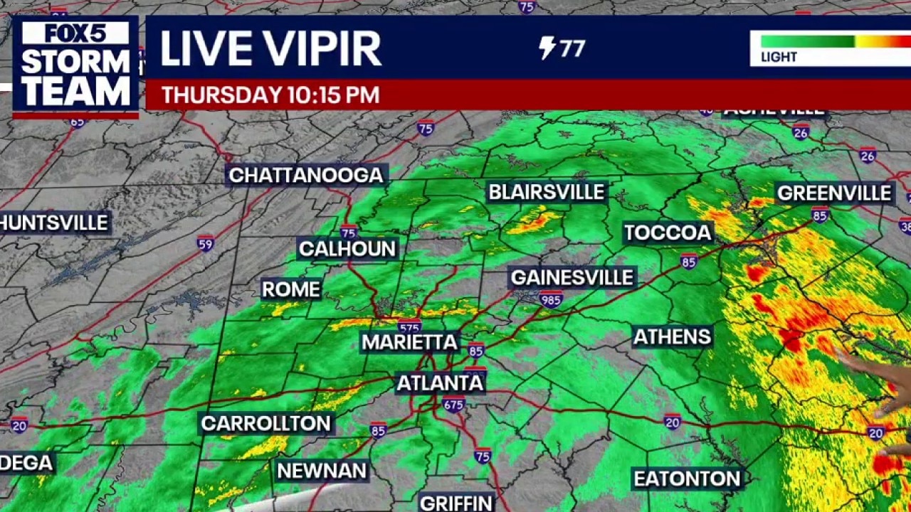
The low-pressure system carrying the remnants of Tropical Storm Arthur moved northeast from the coast of Texas to wreak atmospheric havoc all over the region. The slow-moving tropical cell produced severe downpours, straight-line winds, road flooding, and several isolated spin-up tornadoes throughout the afternoon.
A widespread flood watch remains active through Friday evening for metro Atlanta and central and southern patches of North Georgia.
Local weather indicators track the heaviest rain showers pooling south of Blairsville, as well as stretching through northwest Cobb County, Polk County, Carrollton, and Villa Rica. Public works departments cautioned that pooling water will create hazardous driving conditions well into the night.
High wind advisories
Why you should care:
A concurrent wind advisory remains active along the Interstate 20 corridor and southward. Severe gusts are expected to hit speeds up to 35 mph through early Friday morning.
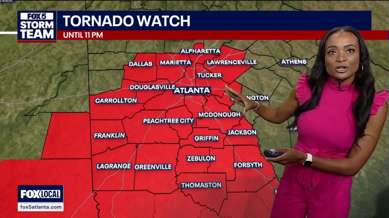
The combination of heavily saturated soil and high-velocity winds expands the immediate threat of falling trees and snapping limbs. While a previous tornado watch blanketed a good portion of the viewing area in red, the immediate tornado threat has shifted eastward and is expected to expire shortly.
Shifting regional fronts
What's next:
The line of stronger storms is tracking toward the northeast and will gradually clear out of the state during the overnight hours. Friday morning will bring lingering cloud cover, leading to a stable mix of sun and clouds by Friday afternoon.
The vast majority of North Georgia will stay dry for Friday and Saturday, with temperatures remaining stable in the middle to upper 80s. However, the far southwestern corner of the viewing area—including neighborhoods from LaGrange through Thomaston in Upson County, Meriwether County, and Heard County—could still see very isolated storms Friday afternoon. Wet weather patterns are modeled to return to the regional forecast by Sunday and Monday.
Unknown storm damage
What we don't know:
Emergency management officials have not released a formal regional damage estimate or confirmed the number of residential power outages triggered by the wind gusts.
Original Story
The FOX 5 Storm Team has declared Thursday a Storm Alert Day as tropical moisture spreads across metro Atlanta and North Georgia. While flooding remains the primary concern, forecasters are also increasingly concerned about isolated severe thunderstorms and brief tornadoes developing later in the day.
Rain was already moving through parts of metro Atlanta and North Georgia late Thursday morning, but meteorologists say the most significant impacts are expected this afternoon and evening.
LIVE UPDATES
9:33 P.M.
Take a look at some of the storm damage seen across North Georgia below.
9:10 P.M.
A tractor trailer is blocking all lanes on the I-75 N Express Lanes at Terrell Mill Rd. due to a stall.

All lanes are blocked on the I-75 N Express Lanes at Terrell Mill Rd. due to a stall. (Credit: GDOT)
8:50 P.M.
A tornado warning has been issued for Putnam, Baldwin, Hancock and Jones counties. It is set to expire at 9:15 p.m.
8:05 P.M.
The tornado watch has been canceled for Atlanta and southeastern areas of the city.
7:45 P.M.
A tornado warning for Monroe, Upson, Bibb and Crawford counties has been extended until 8:15 p.m.
7:20 P.M.
A tornado warning has been issued for Crawford, Talbot, Taylor, Upson counties until 7:45 p.m.
7:05 P.M.
Over 1,00 flights are facing delays at Hartsfield-Jackson International Airport.

Hartsfield-Jackson International Airport flight delays as of 7:05 p.m. on June 18, 2026. (Credit: Flight Aware)
7:04 P.M.
High winds and heavy rainfall have left approximately 70,000 reported power outages across Georgia. Local utility grids were hit hard in the metro area, with out-of-service tallies jumping significantly in key counties:
Fulton and DeKalb counties: Upwards of 10,000 outages
Gwinnett County: 7,500 outages
Henry County: 5,000 outages
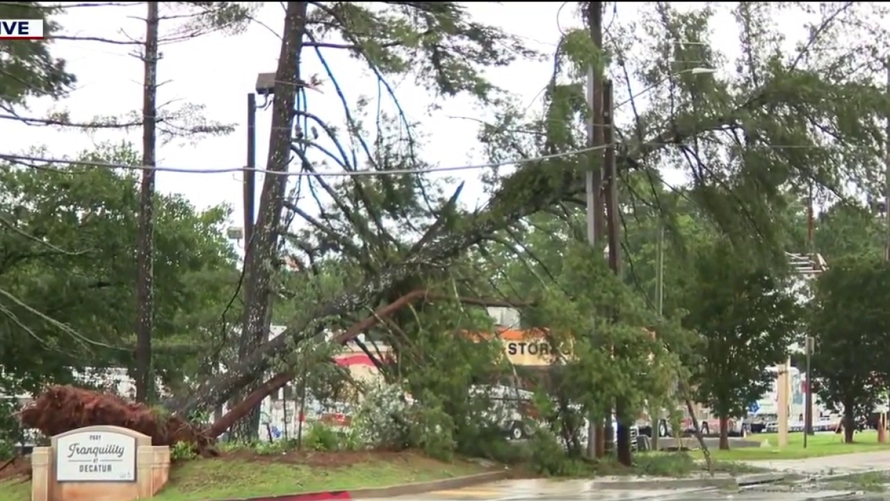
The severe cell also caused physical damage on the east side of the metro area. In DeKalb County, a large tree crashed onto a power line along Candler Road. Police cars blocked off the entire block with yellow tape, stopping traffic and causing massive gridlock on routes leading into Flat Shoals Parkway.
Severe storms cause damage across metro Atlanta
A brutal round of severe weather hammered north Georgia on Thursday, leaving 70,000 people in the dark and knocking down trees on major commuter routes.
7:00 P.M.
The tornado warning for southeastern Meriwether County, west central Upson County and northwestern Talbot County has expired.
6:50 P.M.
Downed trees and power outages are being reported across metro Atlanta including a downed tree and powerlines on Candler Road in DeKalb County near I-20.
6:41 P.M.
A tornado warning has been issued for southeastern Meriwether County, west central Upson County and northwestern Talbot County.
The warning remains in effect until 7 p.m.
Impacted locations include Manchester, Woodbury, Warm Springs, Flint Hill, and Raleigh.
5:55 P.M.
Nearly 50,000 power outages are being reported across North Georgia on Thursday evening as severe storms rain down.

Nearly 50,000 people are without power across North Georgia as of 5:55 p.m. on June 18, 2026. (Credit: Georgia Power)
5:35 P.M.
Severe thunderstorm warning extended for metro Atlanta counties until 6:30 p.m. This includes Gwinnett County, Clarke County, Hall County, Jackson County, northwestern Oconee County, Barrow County, southeastern Lumpkin County, Banks County, Forsyth County, White County, northeastern Fulton County.
Impacted locations included Gainesville, Lawrenceville, Winder, Monroe, Jefferson, Commerce, Cumming, Dahlonega, Cleveland, Watkinsville, Homer, Danielsville, Athens, Mountain Park, Peachtree Corners, Roswell, Johns Creek, Alpharetta, Milton, and Duluth.
5:30 P.M.
The FOX 5 Storm Team is tracking a line of severe storms as it rolls through Georgia.
Severe storms roll through metro Atlanta and north Georgia
A line of storms is rolling through north Georgia on Thursday, forcing flight groundings at the world's busiest airport and leaving local roads waterlogged during a storm alert day.
5:20 P.M.
A ground stop is in effect at Hartsfield-Jackson International Airport until at least 5:45 p.m.
5:00 P.M.
A severe thunderstorm warning has been issued for all metro Atlanta counties until 5:30 p.m. This includes central Fulton County, DeKalb County, Gwinnett County, southeastern Cobb County, central Henry County, northern Clayton County, Newton County, Jasper County, and northeastern Monroe County.
Impacted locations include Atlanta, Marietta, Douglasville, Lawrenceville, McDonough, Decatur, Conyers, Monroe, Covington, Eatonton, Jackson, Madison, Monticello, Peachtree Corners, City of South Fulton, Sandy Springs, Roswell, Johns Creek, Alpharetta, and Smyrna.
Severe weather risk upgraded
The Storm Prediction Center upgraded much of metro Atlanta and areas along and south of the Interstate 85 corridor to a Level 2 of 5, or slight risk, for severe weather.
What they're saying:
The risk area includes Atlanta, LaGrange, Newnan, Griffin, McDonough, Covington, Conyers, Lawrenceville, Athens, Commerce and numerous surrounding communities.
The greatest severe weather threat will be from brief spin-up tornadoes that can develop quickly within tropical rain bands. The window for those storms is expected to be between 3 p.m. and midnight.
"The threats will exist," FOX 5 Storm Team meteorologist Alex Forbes said. While the tornado threat remains relatively low, he noted that a handful of tropical tornadoes cannot be ruled out.
In addition to tornadoes, isolated damaging wind gusts and scattered power outages are possible.
Rising flood dangers
What we know:
Heavy rainfall continues to be the primary threat across much of Georgia.
A Flood Watch remains in effect for dozens of counties across north, central and west-central Georgia, including much of metro Atlanta.
Forecasters expect widespread rainfall totals of 2 to 4 inches, with some communities potentially receiving more than 5 inches before the system moves out.
The Weather Prediction Center has also placed parts of metro Atlanta and North Georgia under a Level 3 of 4 risk for excessive rainfall, signaling an elevated threat for flash flooding.
Because the ground is already saturated from recent rain, creeks, streams and low-lying roads could flood quickly.
A Flood Watch is in effect from Thursday morning through late Friday morning for Baldwin, Bibb, Bleckley, Butts, Crawford, Crisp, Dooly, Houston, Jasper, Jones, Monroe, Peach, Pulaski, Putnam, Twiggs, Wilkinson, Greene, Hancock, Washington, Barrow, Cherokee, Clayton, Cobb, DeKalb, Douglas, Fayette, Forsyth, Gwinnett, Henry, Morgan, Newton, Rockdale, Fulton, Walton, Oconee, Bartow, Carroll, Haralson, Paulding, Polk, Chattahoochee, Coweta, Harris, Heard, Lamar, Macon, Marion, Meriwether, Muscogee, Pike, Schley, Spalding, Stewart, Sumter, Talbot, Taylor, Troup, Upson and Webster.

Evening commute could be messy
The heaviest rain is expected to arrive during the afternoon and evening hours, creating the potential for dangerous travel conditions.
FOX 5 Atlanta Meteorologist Greg Majesky said rain and storms will increase throughout the afternoon before peaking during the evening commute and continuing into the overnight hours.
"This is just the warm-up act," Majesky said while tracking developing rain bands Thursday morning. He warned that the combination of heavy rain and isolated severe storms could create a "problematic rush hour."
Drivers are encouraged to avoid flooded roadways and allow extra travel time Thursday afternoon and evening.
Atmospheric vacuum effect
Big picture view:
A tropical disturbance moving inland from the Gulf Coast is interacting with a cold front pushing down from Canada. This setup forms a atmospheric conveyor belt that streams highly unstable, moisture-packed air directly into Georgia. The system will slowly push east, but the tropical ingredients will linger long enough to keep weather conditions active through the end of the week.

Heavy local downpours
Local perspective:
This incoming tropical wave brings a high potential for torrential downpours rather than scattered summer showers. Localized downpours will dump heavy amounts of rain over short periods, which will quickly fill up creeks and low-lying roads. The highest rain totals are expected to target the southern suburbs of metro Atlanta and central Georgia.

Georgia Power says it's ready
What they're saying:
Georgia Power said crews are prepared to respond to storm-related outages as conditions safely allow. The utility warned that saturated ground, heavy rain and gusty winds could bring down trees and damage power lines, leading to scattered outages. Customers are encouraged to charge devices, monitor weather updates and avoid downed power lines, which should always be treated as energized and dangerous. Click here for safety tips.
Looking ahead
What we know:
Conditions should gradually improve after midnight as the heaviest rain shifts east.
Showers and storms will remain possible Friday, but forecasters expect the flood threat to diminish heading into the weekend.
Historic June chill
By the numbers:
The latest multi-day outlook shows tropical moisture dominating the end of the workweek before a brief break arrives.
Metro Atlanta:
- Thursday: High 82, widespread heavy rain and thunderstorms.
- Friday: High 85, numerous thunderstorms and heavy downpours.
- Saturday: High 89, a few lingering afternoon storms.
- Sunday: High 91, isolated afternoon showers.
- Monday: High 90, scattered thunderstorms.
- Tuesday: High 89, scattered thunderstorms.
- Wednesday: High 91, typical summer afternoon pop-up storms.
North Georgia:
- Thursday: High 76, scattered heavy rain and storms.
- Friday: High 78, isolated severe storms possible.
- Saturday: High 82, clearing skies and drier conditions.
- Sunday: High 84, mostly sunny with an isolated storm.
- Monday: High 83, scattered afternoon showers.
- Tuesday: High 84, scattered showers and storms.
- Wednesday: High 85, typical afternoon pop-up storms.

Father's Day sunshine
What's next:
The bulk of the tropical energy will push east of Georgia by early Saturday morning, allowing the flash flood threat to expire. A weak cold front moving in from the north will shunt the deep moisture further south into central and southern Georgia. This brings a brief return to drier weather for most of north Georgia this weekend before typical summer humidity returns next week.
The Source: The information in this story was gathered from FOX 5 Storm Team meteorologist Jonathan Stacey, who tracked the developing tropical low-pressure system and analyzed local computer models, as well as official hazard maps and discussion logs from the National Weather Service. This story was updated on Thursday morning.