

Atlanta Memorial Day weekend forecast: Widespread North Georgia rain
Memorial Day weekend forecast
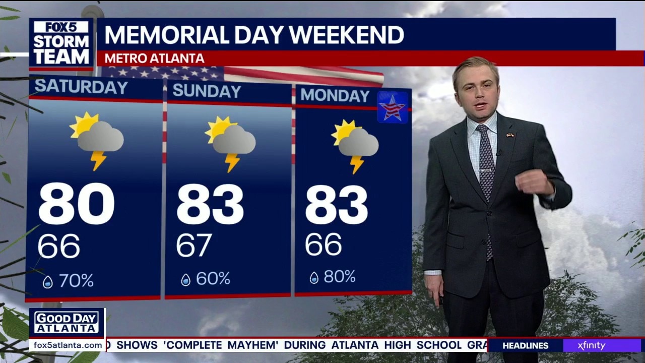
FOX 5 Storm Team Meteorologist Alex Forbes says to expect daily shower and storm chances, but not washouts in Metro Atlanta.
ATLANTA - Widespread showers and thunderstorms are set to disrupt holiday plans across north Georgia and metro Atlanta lingering through the long Memorial Day weekend.
Unsettled holiday outlook
What we know:
A highly unsettled weather pattern has established itself over the region, driven by continuous moisture streaming in from the Southwest.
This setup will trigger multiple rounds of heavy rain and thunderstorms over the next several days.
The FOX 5 Storm Team warns that training storms could drop massive amounts of rainfall.
Because the ground is already saturated from rainfall earlier in the week, localized flash flooding and urban flooding are major concerns.

Saturated soil danger
What they're saying:
FOX 5 Storm Team meteorologist Jonathan Stacey is keeping a very close eye on the potential for damaging wind gusts, which stand out as the primary severe concern for Saturday.
Even though a widespread severe weather outbreak is not anticipated, meteorologists emphasize that it does not take much wind to knock over trees when the soil is completely soaked.
Furthermore, frequent and prolific lightning will accompany these holiday weekend storms.
Fortunately, the severe threat is expected to drop significantly for Sunday and Monday, transitioning the system into a purely heavy rainmaker.

Tracking the downpours
Timeline:
Storms will move through the state in waves over the multi-day holiday period.
- Saturday morning: Early morning moisture brings a round of broken showers, primarily favoring communities to the north and east of the Atlanta perimeter.
- Saturday midday into afternoon: A broken band of heavy showers pushes directly through the metro area, anchoring in place for a few hours. Meanwhile, brief breaks of sunshine are possible across west Georgia and the south side.
- Saturday evening: Stronger thunderstorms stretch eastward, ringing and wreaking havoc with heavy downpours anywhere from Spalding County all the way up to Athens before gradually calming overnight.
- Sunday morning: A relatively calm, quiet start to the day may offer the best and driest outdoor window of the entire weekend, despite a few passing morning showers.
- Sunday afternoon: Showers and storms return in full fashion with only modest breaks in between.
- Monday afternoon: After a decent morning, skies turn dark again by the late afternoon as another round of widespread thunderstorm activity takes over.

Trapped in moisture
Big picture view:
The active weather is the result of North Georgia being sandwiched in a classic summer-like pattern.
Deep tropical moisture is funneling directly into the state from the south and southwest, meeting up with a stalled frontal boundary near the northwest corner of Georgia.
This pipeline of moisture keeps water vapor levels well above average for late May, creating a persistent fuel source that will keep the rain pattern locked in place straight through the remainder of the month.

Multiplying rainfall totals
Local perspective:
Over the past three days, Northwest and Northeast Georgia have already picked up significant splotches of heavy accumulation, including localized flash flooding in downtown Atlanta.
Over the coming three-day holiday period, an additional swath of heavy rain will coat the entire area.
Towns located to the east of Atlanta are expected to see the bulk of the highest totals, where some spots could easily pick up 4 to 5 inches of rain.
Communities to the west of town will not be left out, as they are on track to receive another 1 to 3 inches of rainfall.
Protecting property and power
Why you should care:
With several inches of additional rain falling on top of incredibly soggy ground, tree roots will lose their grip easily.
When wind gusts pop up during afternoon storms, residents should expect downed trees and subsequent disruptions to the local power grid.
In addition to securing patio furniture from gusty winds, travelers and backyard grillers should prepare for sudden indoor delays.
Prolific lightning will make outdoor activities highly dangerous when these storms start popping in the afternoon.
Seven-day outlook
By the numbers:
The daily rounds of rain will keep temperatures slightly tempered but very muggy through next week.
Metro Atlanta 7-Day Forecast:
- Saturday: High 82 / Low 66 / Widespread storms (90%)
- Sunday: High 81 / Low 66 / Showers and storms (90%)
- Monday: High 83 / Low 66 / Afternoon storms (80%)
- Tuesday: High 88 / Low 68 / Scattered storms (40%)
- Wednesday: High 89 / Low 65 / Isolated storms (20%)
- Thursday: High 87 / Low 66 / Mostly cloudy (30%)
- Friday: High 88 / Low 67 / Part cloud (20%)
North Georgia 7-Day Forecast:
- Saturday: High 76 / Low 61 / Widespread storms (100%)
- Sunday: High 75 / Low 60 / Heavy rain and storms (100%)
- Monday: High 79 / Low 61 / Rain likely (80%)
- Tuesday: High 83 / Low 62 / Passing storms (40%)
- Wednesday: High 83 / Low 60 / Scattered showers (30%)
- Thursday: High 82 / Low 61 / Mix of sun and clouds (20%)
- Friday: High 84 / Low 62 / Partly sunny (20%)
Clearing out next week
What's next:
The relentless multi-day rain train will finally begin to lose its steam by the middle of next week. High pressure trying to build over the eastern U.S. will slowly help push the deepest moisture out of the area. While central and north Georgia will remain somewhat hot and muggy, rain chances will drop down significantly to typical summer levels by Tuesday and Wednesday, allowing the region to finally dry out.
Timing your outdoor holiday plans
Timeline:
If you are trying to squeeze in outdoor activities, pool time, or travel this holiday weekend, timing will be everything as storm activity shifts over the next few days.
- Friday and Saturday: Rain started the morning primarily over North Georgia and the mountains. Scattered storms will increase in coverage during the late afternoon and evening, creating a messy setup tonight. The safest time to head outdoors on Friday and Saturday will be during the late morning and early afternoon hours.
- Sunday and Memorial Day Monday: A slight weather shift is expected. Holiday mornings should stay largely dry, but the afternoons and evenings will quickly turn stormy. Rain remains highly likely through at least Monday.
Severe weather threat
Dig deeper:
As storm chances increase late Friday afternoon and evening, the risk for severe weather cannot be entirely ruled out. Forecasters note this is not a major severe weather threat—meaning tornadoes are not a concern. However, individual storms could "pulse" up to severe levels, capable of producing localized damaging winds or hail. Even non-severe thunderstorms will still threaten holiday plans with frequent lightning and heavy downpours.

This is why the Downtown Connector flooded during rush hour
Flash flooding stranded multiple motorists on the Downtown Connector on Wednesday afternoon during the peak rush hour commute.
The Source: The information in this story was gathered from a FOX 5 Atlanta morning weather report by Meteorologist Jonathan Stacey detailing the Memorial Day holiday weekend forecast.