

Weather alert: Georgia tornado confirmed; Strong storms bring down trees, power lines

Sunday morning weather forecast
After a rough start to Sunday morning, the storms have moved out of Atlanta and the skies are clearing. Today's high is expected to be around 64 degrees.
ATLANTA - Strong storms swept through metro Atlanta and North Georgia on Sunday morning.
The National Weather Service has confirmed a short-lived EF-0 tornado touched down in Fayette County early this morning, causing damage near the Woolsey area. The event occurred at approximately 4:38 a.m., coinciding with radar data showing a tornado debris signature in the area. The estimated wind speed was 80 mph.
Video footage from the scene reveals downed tree limbs and snapped trees, consistent with storm-related damage. Weather experts analyzing radar imagery from just before 5 a.m. have identified a significant debris field at the site of the destruction.

Tornado debris in Fayette County
The NWS has confirmed that a tornado touched down in Fayette County at 4:38 a.m. Sunday morning.
A tornado watch was in effect for much of the morning for metro Atlanta. That watch was canceled before 9 a.m.
A Tornado Watch for the following counties was in effect until 1 p.m.: Bryan, Bulloch, Burke, Candler, Columbia, Effingham, Elbert, Franklin, Habersham, Hart, Jenkins, Liberty, Lincoln, Long, McIntosh, McDuffie, Rabun, Richmond, Stephens, and Tattnall.

Minor damage reported after overnight storms
Minor damage has been reported in several areas after storms swept through Georgia and metro Atlanta during the overnight and early morning hours of Dec. 29.
Several thousand Georgia Power customers were left without power after the storms after trees fell on power lines etc. Click here for Georgia Power's outage map.
Shortly after 11 a.m., there were approximately 7,500 Fulton County customers without power; approximately 1,900 in DeKalb; and almost 2,500 in Cobb County.

Update on storm damage in metro Atlanta
Here's a look at some of the storm damage in metro Atlanta. Tornadoes touched down in several states and at least 2 people are dead and several others injured. No serious injuries reported at this time in North Georgial. Ariyl Onstott reporting.
If you have experienced damage in your area or on your property, please let us know by email newstipsatlanta@fox.com. Please include photos and/or video if available.
EARLIER STORY
Metro Atlanta is bracing for a wave of strong to severe storms overnight into the early morning hours of Sunday. While this is nothing we haven't seen before, it's been a while since a system of this type has moved through the state.
The same severe weather outbreak affecting parts of Mississippi, Louisiana and Texas is expected to move eastward, toward North Georgia Sunday morning. What we'll get shouldn't be nearly as intense as what our western neighbors have experienced.
The King and Queen buildings in Sandy Springs are covered by fog on Dec. 28, 2024.
On Saturday evening, visibility took a hit as temperatures continued to warm, reaching the 60s during the overnight hours. The King and Queen buildings in Sandy Springs were barely visible against the dreary skyline.
The threat of severe weather is expected to begin at midnight with isolated cells ahead of the main line.
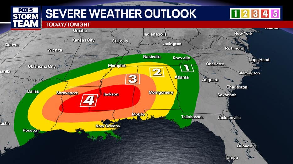
The main squall line will start crossing the Alabama-Georgia state line around 4 a.m. It will take from 4 a.m. until 9 a.m. for the line to move through all of North Georgia. The worst weather is expected in the metro area between 3 and 5 a.m. Areas north and northeast of Atlanta, such as Gainesville and Cornelia, could see over two inches of rainfall, while the metro area may receive over half an inch.
Due to the timing of this system, it is important to have a way to receive weather alerts overnight that will wake you up. This could include wireless emergency alerts on your phone or a weather radio.
Keep up with the latest by downloading the FREE FOX 5 Storm Team app and following @FOX5StormTeam on Twitter
Saturated soils, combined with heavy rainfall, could lead to localized flash flooding. Strong winds associated with these storms may bring down trees and power lines, and isolated, brief tornadoes cannot be ruled out, particularly in areas south of Atlanta where conditions will be most conducive.
The storm is expected to clear by noon Sunday, with gusty winds exceeding 20 mph. Temperatures will rise to around 67 degrees, which is average for this time of year.
New Year's Eve weather forecast
The extended forecast shows quieter weather ahead, with a slight chance of showers on New Year's Eve and clear skies on New Year's Day.
The Source: FOX 5 Atlanta Storm Team meteorologists Alex Forbes and Julie Martin contributed to this story out of Atlanta.