

Line of severe storms drenches North Georgia Sunday
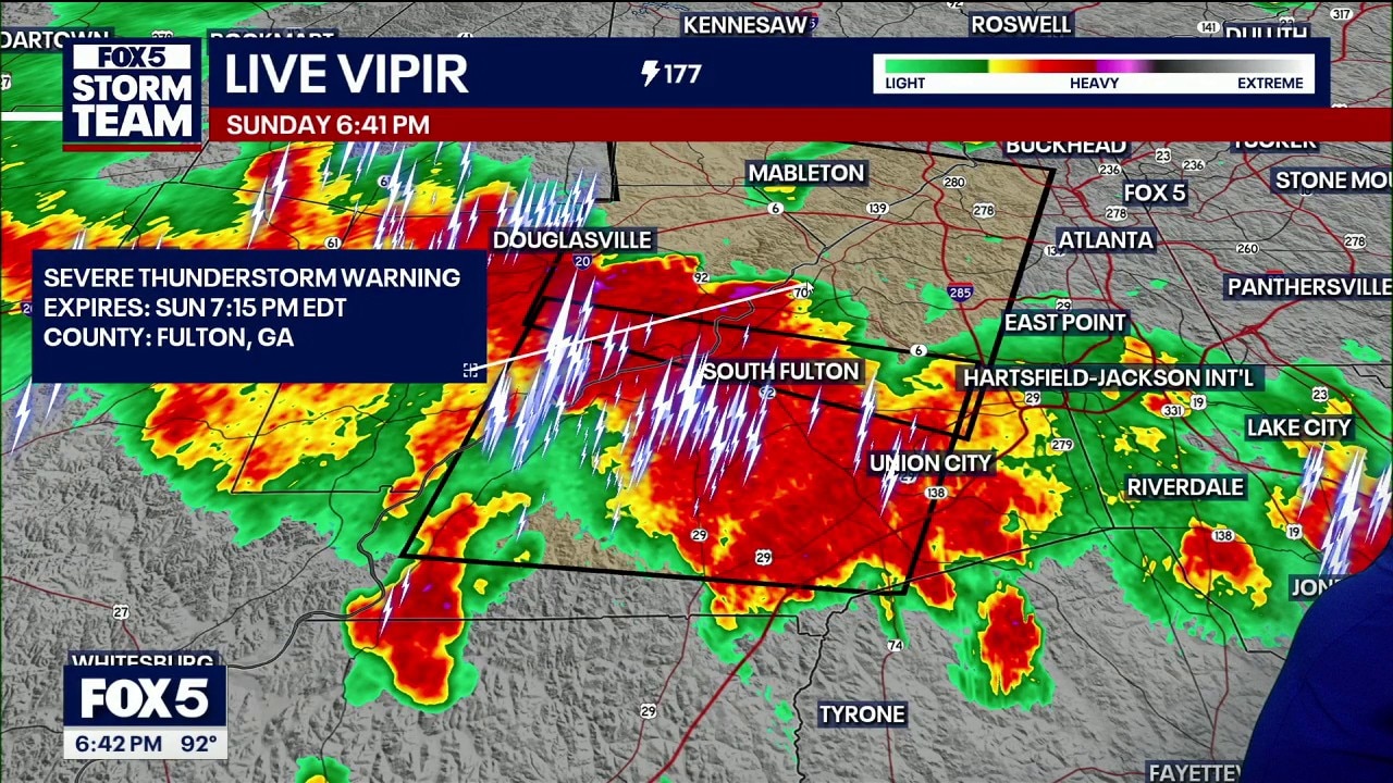
Sunday evening weather forecast
A dangerous line of severe thunderstorms is pushing across north Georgia on Sunday evening, packing damaging winds, localized hail, and torrential rainfall.
ATLANTA - A dangerous line of severe thunderstorms is pushing across North Georgia on Sunday evening, packing damaging winds, localized hail, and torrential rainfall.
What we know:
A formal ground stop is in effect at Hartsfield-Jackson International Airport as severe weather directly impacts the airfield. The flight restrictions hit during one of the busiest travel days of the season.
A powerful line of strong storms is pushing directly along the western half of the I-20 corridor. Because of the intense weather setup, two severe thunderstorm warnings are currently in play until 7:15 p.m. Sunday.
These warnings are primarily driven by the threat of damaging wind gusts that could cause tree limbs to snap into local roadways.
The system encompasses a substantial portion of Fulton County, tracking heavily west and north of Metro Atlanta. The severe cells are producing intense lightning, heavy downpours, and moderate-sized hail.
The broader thunderstorm threats will remain active across metro counties through the rest of the evening
Interstate 20 corridor storms
The storm system is causing widespread disruptions on local roads and major thoroughfares. Drivers traveling along the busy stretch of the I-20 corridor are being urged to exercise extreme caution. The storms are producing heavy downpours that could trigger sudden localized flooding on roadways, alongside moderate hail and high wind gusts capable of dropping tree limbs into traffic lanes.
The primary weather threat has shifted directly to the I-20 corridor, where two outflow boundaries merged to form an expansive line of strong storms.
Georgia severe weather threat
What we don't know:
Meteorologists cannot pin down the exact locations where the strongest storms will hit on Sunday afternoon. While a high number of residents will experience rainfall, the precise tracking of isolated damaging wind gusts or small hail remains uncertain.
Regional travel impacts
Timeline:
Earlier Sunday afternoon, the strongest storm cells were located farther northwest between Calhoun and Chattanooga.
Outflow boundaries then pushed down from the north and upward from the south, colliding directly along the I-20 corridor around 6:40 p.m.
This collision consolidated a violent line of weather stretching from Buchanan and Douglasville through Powder Springs, tracking right over Hartsfield-Jackson International Airport and pushing into Riverdale and Henry County.
Big picture view:
While dangerous storms assault the metro counties, the southeastern corner of the viewing area faces an entirely different climate crisis. A heat advisory remains active as high humidity drives afternoon heat index values anywhere from 100 to 106 degrees Fahrenheit.
Skies will begin clearing out late Sunday night, leading into a mostly dry Monday morning before hit-or-miss, non-severe afternoon storms return to north Georgia.
The Source: The information in this story was gathered from a FOX 5 storm team weather broadcast featuring meteorologist Lauren Robinson, who analyzed live radar data and regional climate maps.