

Metro Atlanta holiday weekend weather to bring daily storm rounds
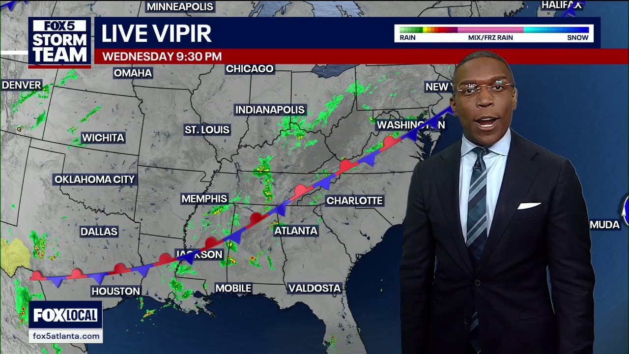
Wednesday night forecast
A stalled cold front has dumped 3.3 inches of rain on downtown Atlanta, causing severe flash flooding while leaving the airport completely dry. The FOX 5 Storm Team tracks a grueling six-day weather pattern that threatens to wash out outdoor plans across North Georgia through the Memorial Day holiday weekend.
ATLANTA - A stalled cold front combined with wide-open tropical moisture from the Gulf of Mexico is bringing daily rounds of heavy downpours and lightning storms to metro Atlanta and north Georgia just in time for the holiday weekend.
Storms cause flash flooding
What we know:
Severe storms left parts of central Atlanta dealing with sudden flash flooding after a massive deluge hit the heart of the city. Radar estimates showed that some areas picked up 3.3 inches of rainfall in an incredibly short window of time.
While a few light showers are lingering through the late-night and early-morning hours, the overall severe weather threat remains low. There are currently no active watches or warnings for the region. However, localized pooling and street flooding remain possible wherever these downpours repeatedly set up.

Brakes on cold front
What they're saying:
"This cold front has completely pumped its brakes, and this thing is not going to move, folks," said the FOX 5 Storm Team. "That is going to be the main issue for us as we go through each and every day, potentially for the next six days."
The team noted that the front will act as a trigger to make storms pop out on either side of it. "We are sitting just to the south of this boundary, so we are getting the warm air moving in. That warm air is going to add insult to injury by making for a very buoyant atmosphere that gives us some pretty impressive, robust storms."

Storm timing broken down
Timeline:
Showers and storms will ebb and flow through the day, with the absolute highest coverage hitting during peak afternoon heating.
- Late Night to Early Morning: Light showers move in from the south and west, greeting the Interstate 75 corridor early in the morning. Pockets of moderate rain will pass over Interstate 575 and Georgia State Route 400, including the mountain foothills.
- Midday Thursday: Expect a brief lull in the activity across the area, giving some parts of north Georgia a chance to see a break.
- Thursday Afternoon: The afternoon sunshine will heat the ground and kick off a renewed wave of storms. While these storms do not look quite as prolific as the ones that flooded central Atlanta, they will still bring sudden downpours.
- Friday and Beyond: Friday will be a total carbon copy of Thursday as the pattern repeats itself for the holiday weekend.
Gulf moisture is unlocked
Big picture view:
A weak ridge of high pressure is breaking down, allowing a subtropical jet stream of wind to tap directly into the Gulf of Mexico. This wide-open conveyor belt of moisture is rushing right into Georgia.
Because there are no strong atmospheric steering winds to push the weather along, a stalled front is just sitting over the region. This boundary will act as a continuous train track for repeating showers to pass over the exact same communities day after day.

Airport misses the rain
Local perspective:
Even though areas inside the city perimeter were swamped by over three inches of rain, the intense storms completely missed Hartsfield-Jackson Atlanta International Airport. Because the official rain gauge missed out on the action, official local rainfall totals will look incredibly small.
Up in the northern suburbs and mountains, spots like White, Pickens, and Fannin counties are in line to pick up some of the heaviest early-morning downpours before the true afternoon storm wave even begins.
Holiday plans look wet
Why you should care:
If you have outdoor plans for the Memorial Day holiday weekend, you will need to keep a very close eye on the sky. These summertime storms can develop rapidly anywhere across north Georgia at almost any time.
Sudden lightning, brief driving distortions on the highway, and localized flooding in poor drainage areas mean you should have an indoor backup plan ready. Outdoor patio furniture might also get tossed around by sudden, localized gusty winds.
Holiday weekend forecast numbers
By the numbers:
Temperatures are running several degrees above normal, making it feel exactly like the middle of summer. Atlanta hit a high of 91 degrees, making it one of the warmest days of 2026 so far, though it fell short of the 1941 record of 94 degrees.
Metro Atlanta 7-Day Forecast:
- Thursday: High: 85 / Low: 68 (Scattered afternoon storms)
- Friday: High: 85 / Low: 67 (Storms likely)
- Saturday: High: 85 / Low: 68 (Scattered storms)
- Sunday: High: 86 / Low: 66 (Afternoon downpours)
- Memorial Day: High: 85 / Low: 68 (Holiday weekend storms)
- Tuesday: High: 84 / Low: 67 (Storm chances dropping)
- Wednesday: High: 83 / Low: 68 (Partly cloudy)
North Georgia (Blairsville) 7-Day Forecast:
- Thursday: High: 79 / Low: 62 (Heavy mountain showers)
- Friday: High: 76 / Low: 61 (Storms likely)
- Saturday: High: 76 / Low: 62 (Scattered rain)
- Sunday: High: 75 / Low: 60 (Afternoon showers)
- Memorial Day: High: 78 / Low: 50 (Scattered downpours)
- Tuesday: High: 81 / Low: 56 (Rain chances fading)
- Wednesday: High: 82 / Low: 65 (Partly cloudy)
Storm chances start fading
What's next:
This wet, tropical pattern will keep a tight grip on Georgia straight through the long holiday weekend. However, there is light at the end of the tunnel. By the time we get into next Tuesday and Wednesday, the atmospheric energy will begin to pull away, and storm chances will finally start trending downward across the region.
The Source: The details in this article were provided by the FOX 5 Storm Team. The National Weather Service contributed to this report.