


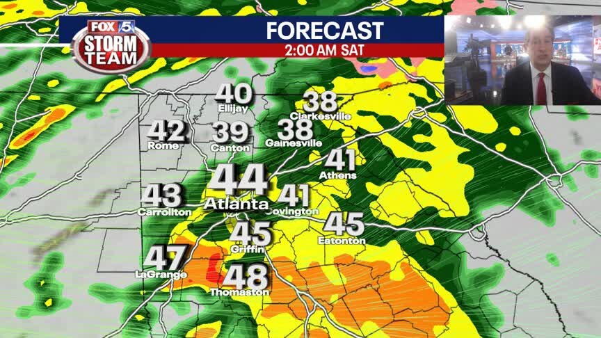
Saturday weather forecast
Dreary day across north Georgia. Strong storms possible beginning of the week.
Dreary day across north Georgia. Strong storms possible beginning of the week.

Friday evening weather forecast
Evening weather forecast for Jan. 5. 2024
Evening weather forecast for Jan. 5. 2024
Friday Night Weather Update
Rain likely tonight with periods of heavy rain. Small chance for some freezing rain in extreme NE GA. Temps will hold in the upper 30s to low 40s by Saturday morning. Breaks in the clouds Saturday afternoon with highs back into the 50s. More rain and storms by Tuesday. Here is the breakdown.
Rain likely tonight with periods of heavy rain. Small chance for some freezing rain in extreme NE GA. Temps will hold in the upper 30s to low 40s by Saturday morning. Breaks in the clouds Saturday afternoon with highs back into the 50s. More rain and storms by Tuesday. Here is the breakdown.

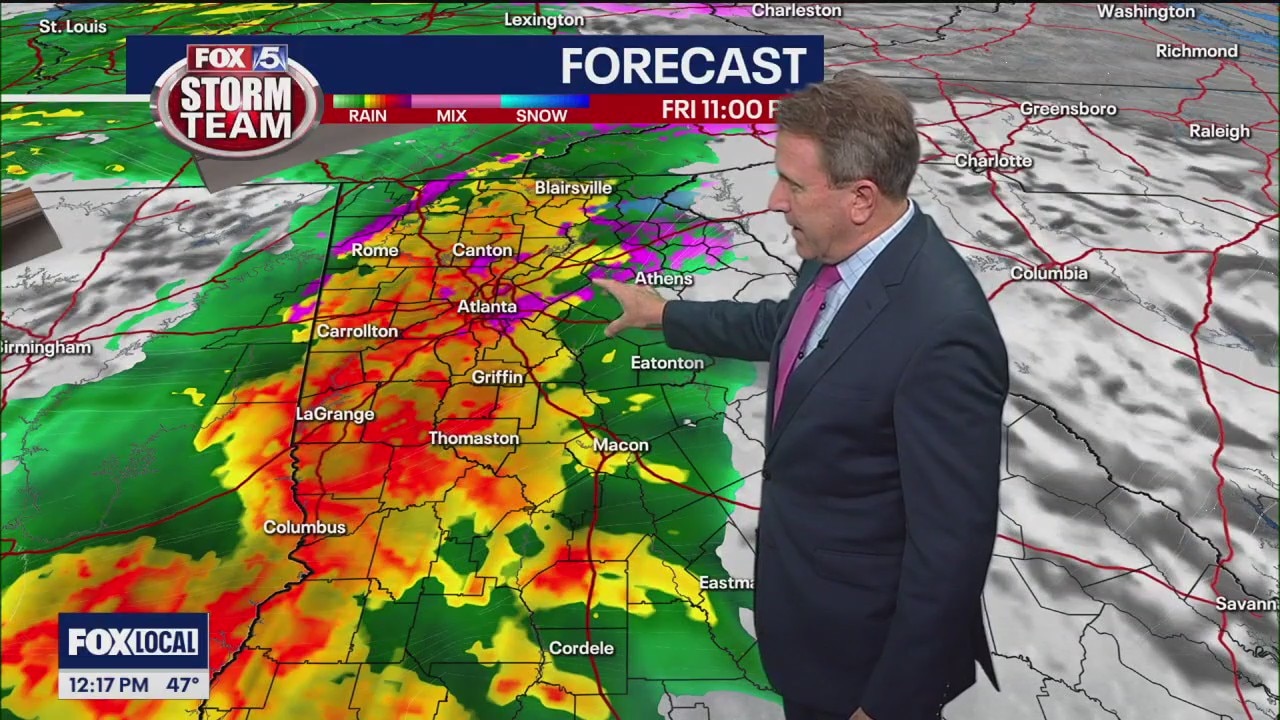
Friday midday weather forecast
Rain arrives tonight. Storms possible Tuesday.
Rain arrives tonight. Storms possible Tuesday.

Friday morning weather forecast
Today will stay dry, but cold rain and possible heaven winds are on their way tonight
Today will stay dry, but cold rain and possible heaven winds are on their way tonight

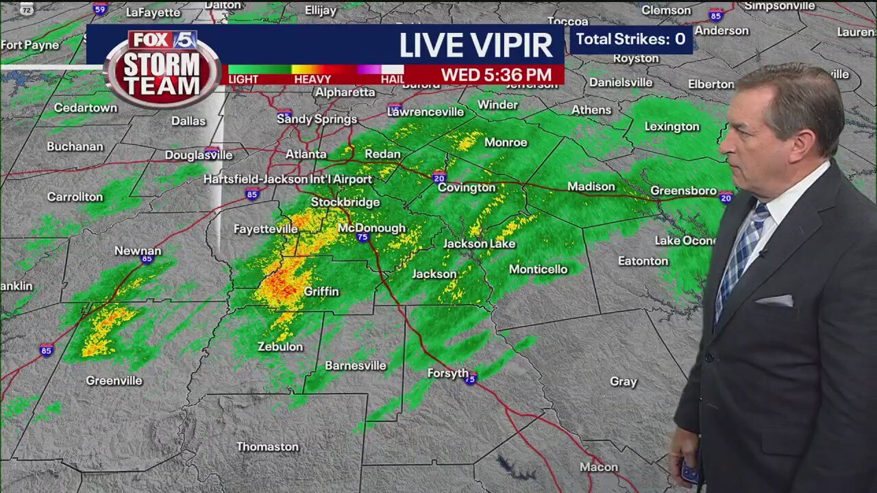
Thursday night forecast
Friday will see increasing clouds throughout the day and breezy conditions. Highs will land around 50. Rain arrives late Friday night and through early Saturday morning. Highs for the weekend will be in the 50s. The next big storm system arrives on Tuesday with the prospect of heavy rain and possible storms.
Friday will see increasing clouds throughout the day and breezy conditions. Highs will land around 50. Rain arrives late Friday night and through early Saturday morning. Highs for the weekend will be in the 50s. The next big storm system arrives on Tuesday with the prospect of heavy rain and possible storms.

Thursday Night Weather Update
Clear and chilly overnight with Friday morning lows freezing and below. Increasing clouds by afternoon with highs around 50. Rain likely Friday night and into Saturday morning, at times locally heavy. A brief wintry mix is possible in NE GA, but no issues expected. Another strong storm system arrives late Monday. Here are the details.
Clear and chilly overnight with Friday morning lows freezing and below. Increasing clouds by afternoon with highs around 50. Rain likely Friday night and into Saturday morning, at times locally heavy. A brief wintry mix is possible in NE GA, but no issues expected. Another strong storm system arrives late Monday. Here are the details.

Thursday afternoon forecast
Clouds will begin to increase Friday afternoon ahead of some beneficial rain Friday night into Saturday morning. It may start as a wintry mix over northeast Georgia, but isn't expected to have a big impact. A changeover to all rain should happen pretty quickly. Overall, just looking at cold, windy, and wet conditions for early Saturday.
Clouds will begin to increase Friday afternoon ahead of some beneficial rain Friday night into Saturday morning. It may start as a wintry mix over northeast Georgia, but isn't expected to have a big impact. A changeover to all rain should happen pretty quickly. Overall, just looking at cold, windy, and wet conditions for early Saturday.
Thursday midday weather forecast
Rain likely Friday night into Saturday morning. Strong storms possible on Tuesday.
Rain likely Friday night into Saturday morning. Strong storms possible on Tuesday.

Thursday morning weather forecast
Sunshine is back today, but it's going to feel cold thanks to the breezy winds that will be sticking around.
Sunshine is back today, but it's going to feel cold thanks to the breezy winds that will be sticking around.

Wednesday evening forecast update
Showers and a few mountain snowflakes will end by early evening and then a clearing trend overnight. We're in for a chilly start to Thursday with lows in the 20s to low 30s. Here's a look at your FOX 5 Storm Team forecast.
Showers and a few mountain snowflakes will end by early evening and then a clearing trend overnight. We're in for a chilly start to Thursday with lows in the 20s to low 30s. Here's a look at your FOX 5 Storm Team forecast.

Wednesday Night Weather Update
Showers and a few mountain snowflakes will end by early evening and then a clearing trend overnight. Chilly start to Thursday with lows in the 20s to low 30s. Sunny, breezy and cool by afternoon with highs near 50. Increasing clouds on Friday and then more rain Friday night into Saturday. Here is the latest outlook.
Showers and a few mountain snowflakes will end by early evening and then a clearing trend overnight. Chilly start to Thursday with lows in the 20s to low 30s. Sunny, breezy and cool by afternoon with highs near 50. Increasing clouds on Friday and then more rain Friday night into Saturday. Here is the latest outlook.
Wednesday evening forecast
Sunshine returns Thursday, but the rain will return Friday night into Saturday afternoon. That will be much more substantial. Here's the latest from the FOX 5 Storm Team.
Sunshine returns Thursday, but the rain will return Friday night into Saturday afternoon. That will be much more substantial. Here's the latest from the FOX 5 Storm Team.
Wednesday afternoon forecast
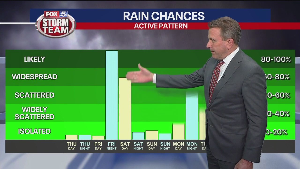
The FOX 5 Storm Team is tracking three rounds of rain expected in the next seven days with one early next week that could see severe storms.
The FOX 5 Storm Team is tracking three rounds of rain expected in the next seven days with one early next week that could see severe storms.

Wednesday midday weather forecast
Few showers Wednesday. Wetter Saturday and Tuesday.
Few showers Wednesday. Wetter Saturday and Tuesday.

Wednesday morning weather forecast
Clouds will increase over the morning and bring with them scattered and light rain for the afternoon.
Clouds will increase over the morning and bring with them scattered and light rain for the afternoon.

Tuesday evening forecast update
Temperatures are expected to hover around freezing. Here's a look at your FOX 5 Storm Team forecast.
Temperatures are expected to hover around freezing. Here's a look at your FOX 5 Storm Team forecast.
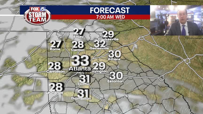
Tuesday Night Weather Update
Increasing clouds into Wednesday with a chilly start as temps will hover around freezing. Cool thru the day with scattered showers by late afternoon, especially south of ATL. Dry and cool thru the week with more rain on Saturday. Here is the breakdown.
Increasing clouds into Wednesday with a chilly start as temps will hover around freezing. Cool thru the day with scattered showers by late afternoon, especially south of ATL. Dry and cool thru the week with more rain on Saturday. Here is the breakdown.

Tuesday evening forecast
There are several chances for rain tonight. Here's when you may be able to expect it to start coming down.
There are several chances for rain tonight. Here's when you may be able to expect it to start coming down.

Tuesday afternoon forecast
2024 is off to a chilly start. Here's a look at your FOX 5 Storm Team forecast.
2024 is off to a chilly start. Here's a look at your FOX 5 Storm Team forecast.