

Atlanta weather: Record heat to 'ring the bell' before weekend severe storm threat
Weekend weather: Record highs to severe storms
Record-breaking temperatures in the 80s will give way to a level one severe weather threat this Saturday night, bringing risks of 60 mph winds and hail.
ATLANTA - North and Central Georgia are bracing for a stretch of record-challenging heat.
This comes as the FOX 5 Storm Team monitors a marginal risk for severe thunderstorms arriving Saturday.
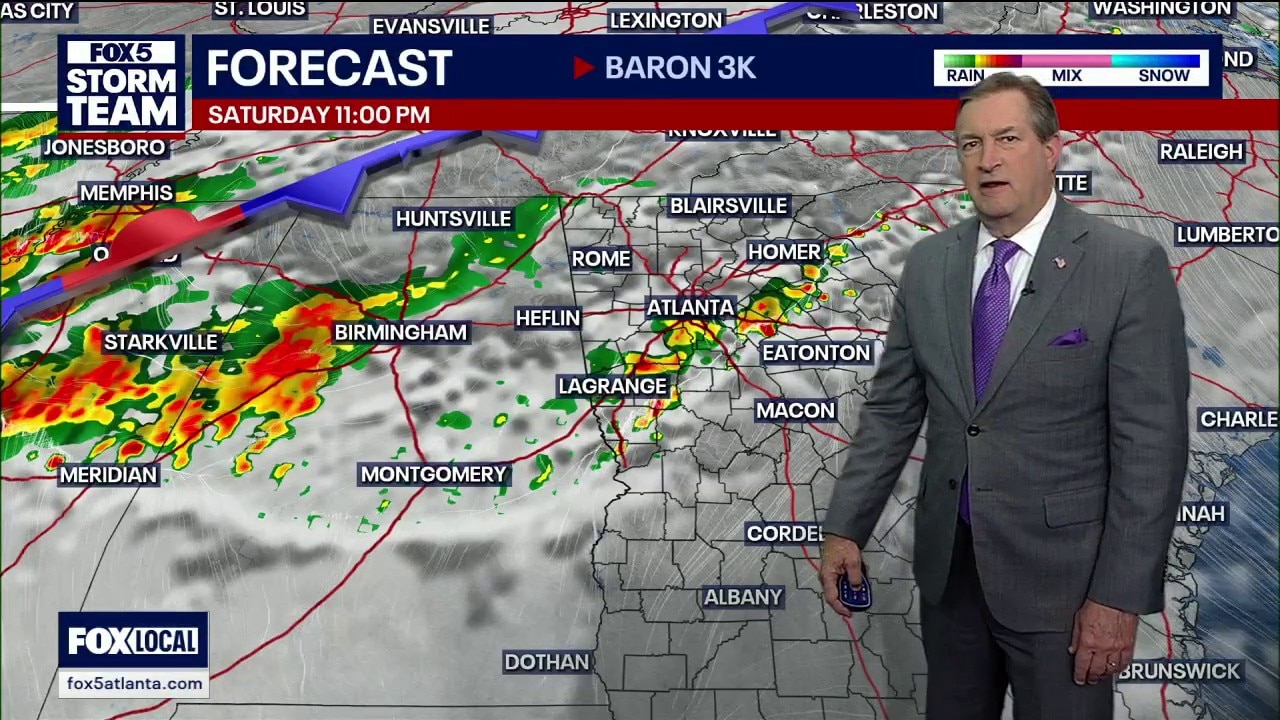
Severe weather possible
What we know:
The FOX 5 Storm Team is monitoring a transition to more active weather, beginning with isolated "summer-like" thunderstorms Friday afternoon. The primary threat arrives Saturday as a Level 1 severe weather risk is triggered for the northern half of the state. According to the FOX 5 Storm Team, these storms will be capable of producing damaging wind gusts up to 60 mph, frequent lightning, and possible hail. Rain chances remain high through Sunday, with a 60 percent chance of widespread showers and thunderstorms as the cold front moves into North Georgia.

‘Running well above that average’
What they're saying:
An expansive subtropical ridge has locked a warm, humid airmass over the region, pushing daytime highs into the low 80s, well above the typical March average of 63 degrees. While Friday remains mostly sunny after the dissipation of morning fog, rain chances will steadily climb through the weekend. The FOX 5 Storm Team expects a 40% chance of storms on Saturday, followed by a more widespread 60% chance on Sunday.
FOX 5 Storm Team Chief Meteorologist David Chandley noted the significant departure from normal conditions, stating the weather is "running well above that average high of 63."

Regarding the potential for broken records, Chandley asked, "Is the time to ring the bell? I think we will. In here tomorrow afternoon, with a high of 81. It will get close on Saturday. Tying the record high."
While Saturday carries a severe risk, the timing may work in the region's favor. "The timing for us is after sunset. So we’ve lost a lot of that energy and instability by the time it rolls in here Saturday. I think it’s fairly weak, but we’ll see," Chandley said.
What to expect this weekend
Timeline:
The transition from stagnant warmth to active storm patterns will follow this schedule according to the FOX 5 Storm Team:
- Friday Morning: Patchy dense fog and low clouds develop between 4 a.m. and 6 a.m., persisting until midday.
- Friday Evening: A "random" shower or thunderstorm is possible, primarily near the metro area by 6 p.m.
- Saturday Afternoon: Scattered storms develop; the Level 1 severe risk begins for North Georgia.
- Saturday Night: The primary line of storms moves through after sunset.
- Sunday: Showers and thunderstorms become likely (60% chance) after 1 p.m.

Cold front moves into Georgia
Big picture view:
The FOX 5 Storm Team indicates that a broad cold front will sweep across the eastern U.S. on Saturday. This system brings weakly bolstered kinematics, with wind shear between 20 to 40 knots, which is enough to support organized storm clusters. Because the front will be competing with a persistent ridge of high pressure, it is expected to fizzle out as it moves into Central Georgia by Monday morning.

Highs in the 80s
Local perspective:
Metro Atlanta is forecast to hit 82 degrees on both Friday and Saturday. Further north in Blairsville, highs will stay in the mid-70s, though rain chances are higher. The National Weather Service notes that while rainfall will be patchy, the high moisture levels in the atmosphere could lead to efficient rain production, causing nuisance flooding in isolated areas.

Your weekend hazards
Why you should care:
Outdoor plans may be impacted by lightning and gusty winds up to 60 mph on Saturday afternoon. Drivers should also be wary of "locally thick and dense" fog during the Friday morning commute. Additionally, residents are reminded to set their clocks forward one hour early Sunday morning as Daylight Saving Time begins.

The next 7 days
By the numbers:
The FOX 5 Storm Team is tracking the following daytime highs, nighttime lows, and precipitation chances for the next seven days:
Metro Atlanta
- Friday: High 82°F | Low 63°F (30% chance of storms)
- Saturday: High 82°F | Low 63°F (40% chance of storms)
- Sunday: High 76°F | Low 61°F (60% chance of rain)
- Monday: High 78°F | Low 62°F (50% chance of rain)
- Tuesday: High 83°F | Low 64°F (20% chance of rain)
- Wednesday: High 83°F | Low 58°F (50% chance of rain)
- Thursday: High 71°F (30% chance of rain)
North Georgia (Blairsville)
- Friday: High 76°F | Low 58°F (30% chance of storms)
- Saturday: High 74°F | Low 56°F (60% chance of rain)
- Sunday: High 69°F | Low 53°F (60% chance of rain)
- Monday: High 75°F | Low 56°F (50% chance of rain)
- Tuesday: High 76°F | Low 58°F (30% chance of rain)
- Wednesday: High 76°F | Low 53°F (50% chance of rain)
- Thursday: High 64°F (40% chance of rain)

Start of the workweek
What's next:
The FOX 5 Storm Team forecasts that warmth will rebound quickly on Monday and Tuesday. Tuesday is shaping up to be the warmest day of the year so far, with the potential for temperatures to hit 90 degrees in far southeast Central Georgia. Another system is expected to bring a 60% chance of rain by Wednesday night.
The Source: Information gathered from the FOX 5 Storm Team and the National Weather Service.